Vermont needs to pay more attention to its rivers and may need to rethink development along their banks, the state’s environmental agency said Monday in a report on lessons from the widespread flooding triggered by Tropical Storm Irene.
“Climate data show that Vermont is experiencing more extreme rain events, and that trend is predicted to continue,” according to the report from the Climate Change Team at the Agency of Natural Resources. More frequent heavy rainstorms are “expected to pose a recurrent challenge to our communities.”
The report contained more questions than specific recommendations. Natural Resources Secretary Deb Markowitz said it was designed to get a conversation going. “As our climate warms, we’re going to see much more extreme weather events and we need to be prepared,” she said.
New policies and recommendations could range from a requirement that fuel tanks in flood zones be tied down, so they don’t float away, spewing their hazardous contents, to more conservation of forests and wetlands near rivers so that when flood waters do come, they have more places to be absorbed.
Markowitz spoke of one “success story” along the Otter Creek, which flows north through Bennington, Rutland and Addison counties and into Lake Champlain. Flooding from the creek did much heavier damage in Rutland County and in the Addison County town of Brandon than downstream in Middlebury. Markowitz said her agency’s river experts attribute the difference to a series of wetlands between Brandon and Middlebury that had been preserved.
“The floodwaters were less than half as high when they got to Middlebury, even though there were tributaries adding more (water),” she said. “It wasn’t as dangerous.”
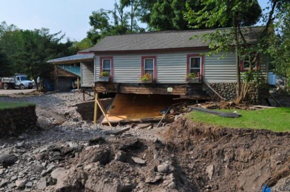
Much of the report was devoted to a summation of the effects of the Aug. 28 storm. Here’s a partial list:
-More than 500 miles of state roads damaged, and about 200 state bridges damaged or destroyed.
-More than 2,000 municipal road segments damaged or destroyed, as well as 280 bridges and 960 culverts.
-More than 200 miles of state-owned railroad track and six bridges damaged.
-State offices flooded, including those of the Agency of Natural Resources and Vermont Emergency Management.
-Significant damage to federal and state fish hatcheries.
-More than 16,000 residents required to boil drinking water after contamination of both public and private water systems.
-Hundreds of hazardous waste spills as basements containing household chemicals were flooded and heating oil tanks became disconnected and lost their contents.
-Seventeen municipal sewage systems compromised, with an estimated 10 million gallons of raw or partially processed waste flowing into rivers.
-About 20,000 acres of farmland flooded.
The state should examine how the built environment of its cities and towns has “imposed on rivers,” it said. Agency engineers testified at a Statehouse hearing recently that straightening river channels and building levies meant to prevent flooding actually can worsen it by speeding river flows.
The report asked, “What parts of our livelihoods or parts of our societies are most vulnerable to disasters like Irene?”
It also said the state should look at how natural features like wetlands and river bank forests can be used to reduce flooding.
And it said state needs to look at what sorts of changes its rivers may see as a result of more frequent flooding.
Was this article valuable?
Here are more articles you may enjoy.
 US Considers Creating Finra-Like Watchdog to Vet Top AI Models
  What Home Age Actually Tells Us About Claims — And What It Doesn’t
  Texas Floods, Canada Smoke and Western Heat Batter US
  After Losing Job and Crypto, Man Falsely Claimed $1.3M From 107 Class Actions
Want to stay up to date?
Get the latest insurance news
sent straight to your inbox.