TALLAHASSEE, Fla. — A tornado spawned by Tropical Storm Nestor damaged homes and a school in central Florida but the storm spared an area of the Florida Panhandle devastated one year ago by Hurricane Michael, authorities said Saturday.
The Polk County Sheriff’s Office said several homes were damaged and Kathleen Middle School had a large section of its roof torn off when the tornado hit late Friday near Lakeland, about an hour’s drive southwest of Orlando.
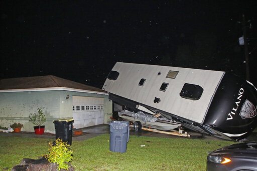
Photos posted by The Ledger newspaper showed a home with a destroyed roof, downed trees, a large recreational vehicle thrown onto its side and vehicles buried under debris. About 10,000 homes were without power.
“Thankfully, we have not had any reported serious injuries,” Sheriff Grady Judd said in a Saturday statement. “However, there are many people dealing with damage to their homes and property this morning, some of it severe.”
In Mexico Beach, where a powerful October 2018 storm nearly wiped out the Panhandle town and left thousands homeless, the mayor said Saturday that Nestor brought some needed rain to a portion of the state suffering from drought, but no damage.
“There have been no issues,” said Mayor Al Cathey, whose city is still recovering. He said the sky Saturday morning was streaked with blue. “I would call us fortunate.”
The state had activated its emergency operations center, but only at its lowest level. In an area that’s recently gone weeks without rain, the storm was seen more as a welcome sight.
The National Hurricane Center said high winds and dangerous storm surge were likely along parts of the northern Gulf Coast. The system could dump from 2 to 4 inches (5 to 10 centimeters) of rain from the central Gulf Coast to the eastern Carolinas and as much as 6 inches (15 centimeters) in spots, forecasters said.
Seawater pushed inland by the storm could rise as much as 5 feet (1.5 meters) as storm surge in Florida’s Big Bend region, much of which is less-developed than the rest of the state’s coast.
Forecasters said Nestor was centered early Saturday about 80 miles (128 kilometers) south-southwest of Panama City, Florida. It had top sustained winds of 50 mph (80 kph) and was moving to the northeast at 17 mph (27). Its center is expected to make landfall about midday Saturday.
A tropical storm warning was in effect from the line between Okaloosa and Walton counties east to Yankeetown, Florida. A previous warning west of the county line was discontinued by Saturday morning. A storm surge warning is in effect for Indian Pass, Florida, to Clearwater Beach, Florida.
The hurricane center said Nestor was expected to head inland across the Panhandle on Saturday morning and cross parts of the Southeast over the weekend before moving into the Atlantic off North Carolina by late Sunday.
Forecasters expect blustery winds and heavy rain in parts of Alabama, Georgia and northern Florida, reaching the Carolinas and Virginia by Sunday.
The Coast Guard said 20-foot (6-meter) seas were possible around Panama City, and dangerous rip currents were possible along beaches during what is still a busy tourism period.
About the photo: A camper rests on top of a boat trailer and the corner of a home as Tropical Storm Nestor passed the area on Saturday, Oct. 19, 2019 in Kathleen, Fla. Nestor was downgraded Saturday after it spawned a tornado that damaged several homes. (Luis Santana/Tampa Bay Times via AP)
Was this article valuable?
Here are more articles you may enjoy.
 US Hits Iran With Strikes, Blockade as Trump Plans Hormuz Charge
  Software Firm CCC Intelligent Solutions Exploring Sale: Reuters
  Citadel Securities Asks to Join Susquehanna Insider-Trading Suit
  Allianz Unit to Cut as Many as 1,800 Jobs in Push to Adopt AI
Want to stay up to date?
Get the latest insurance news
sent straight to your inbox.