The U.S. Northeast, including New York City, will get a brief touch of snow this weekend before a frigid blast of arctic air pushes through the region, leaving winter-weary residents shivering and putting additional stress on power grids and energy prices.
New York’s Central Park could see about a 0.5 inch (1 centimeter) of new snow late Friday before winds rise and the cold descends through the weekend, with conditions that could bring on frostbite in minutes.
Temperatures are forecast to fall to 5F (-15C) Saturday night in New York City, and wind chills will make it feel closer to -10F to -15F, the National Weather Service said.
Across a wider area from West Virginia to most of New York state and northern New England, temperatures and wind chills will be especially frigid. Wind chills are forecast to be -20F to -35F in the upper Hudson Valley and through the Taconics, along the eastern border of New York and adjacent New England.
“A pretty strong arctic front is going to push through during the day Friday into Friday night through Saturday and there will be a little bit of snow ahead of it,” said Marc Chenard, a senior branch forecaster with the US Weather Prediction Center. “Saturday and Sunday is kind of the core of the cold. On Monday we start rebounding but it is still well below average.”
For almost three weeks, the eastern US has been gripped by cold and buffeted by snow storms that caused some power grids to declare emergencies or ask residents to conserve electricity as people sought to turn up their heating.
Temperatures in Central Park failed to reach the freezing point of 32F nine out of 12 days through February 4. So far this month, the average monthly temperature in the city is 9.2F below normal, weather data shows.
Power demand in New York City is expected to stay elevated through next Tuesday, at least. Power usage on the state grid may climb to nearly 23.4 gigawatts on Monday evening, which would slightly exceed the forecasted high for this winter, New York Independent System Operator Inc. data show. On-peak wholesale electricity for the city is at a record so far this year and up 45% from the same time last year, according to average grid day-ahead prices compiled by MCG Energy Solutions LLC.
PJM Interconnection LLC, the operator of the largest US grid that serves 67 million people from New Jersey to Chicago, expects demand to strengthen in the coming days though not as much as during last month’s massive winter storm. On-peak prices so far this year are at a record, at more than double the year-earlier average. The grid has asked generators to protect their units from freezing and to report any change concerns about fuel supply, such as natural gas or oil, according to a cold weather advisory for February 7-9.
The frigid air has also caused complications for transportation – particularly airlines that have to de-ice planes before letting them fly.
It also can pose a serious health risk.
In New York City, at least 17 people have died outside since January 19, with at least 13 of them from hypothermia, Mayor Zohran Mamdani said on Wednesday.
“The dangerously cold wind chills as low as 35 below zero could cause frostbite on exposed skin in as little as 10 minutes,” the National Weather Service said. “Dress in layers including a hat, face mask, and gloves if you must go outside.”
An extreme cold watch stretches from the Appalachian spine of West Virginia, through northern Pennsylvania, into most of New York and then across western and northern New England, Chenard said.
New York City and Long Island don’t quite meet the criteria for a watch, but will certainly be covered by a cold weather advisory as Friday approaches, he said.
Was this article valuable?
Here are more articles you may enjoy.
 Software Firm CCC Intelligent Solutions Exploring Sale: Reuters
 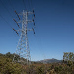 PG&E Says Power Shutoffs Required in California on Wildfire Risk
  Allianz Unit to Cut as Many as 1,800 Jobs in Push to Adopt AI
  Texas Floods, Canada Smoke and Western Heat Batter US
Want to stay up to date?
Get the latest insurance news
sent straight to your inbox.