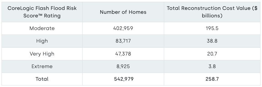
CoreLogic estimated that across the greater Los Angeles area, nearly 543,000 single- and multifamily homes with a combined reconstruction cost value (RCV) of more than $258 billion are at risk of flash flood damage.
Reconstruction cost value is the cost to rebuild a property back to 100%, assuming complete destruction. Not all properties with elevated flash flood risk sustained flood damage. Any structures that were damaged may not have sustained 100% loss up to the full reconstruction value. The number of damaged properties will be a subset of the total 542,979 homes.
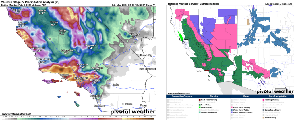
CoreLogic estimated that across the greater Los Angeles area, nearly 543,000 single- and multifamily homes with a combined reconstruction cost value (RCV) of more than $258 billion are at risk of flash flood damage.
Note, the reconstruction cost value in Table 1 does not represent a loss.
Reconstruction cost value is the cost to rebuild a property back to 100%, assuming complete destruction. Not all properties with elevated flash flood risk sustained flood damage. Any structures that were damaged may not have sustained 100% loss up to the full reconstruction value. The number of damaged properties will be a subset of the total 542,979 homes.
The CoreLogic Flash Flood Risk Score™ uses structure data available for the entire U.S. and watershed hydrology to extract hydrologic properties from land information datasets, incorporating probabilistic characteristics of meteorological factors to simulate precipitation impact. Flash flooding factors are then integrated to form an overall projection of flash flood risk for a specific structure or parcel.

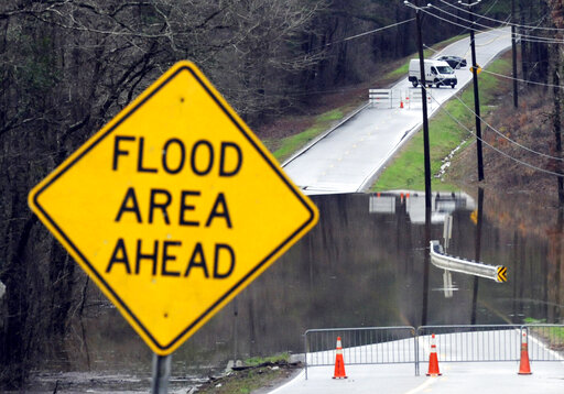
An Explanation of Flash Flooding
Flash flooding occurs when precipitation rates are greater than the speed at which water drains into the ground surface. Several factors influence the ground surface penetration rates:
The amount of impervious surface (e.g., pavement)
- Soil saturation
- Stormwater management system overwhelm
- Precipitation rates
In highly developed regions like the San Francisco Bay Area and Los Angeles area, water is unable to enter the ground and therefore flows over paved surfaces, flooding roads and sidewalks to create dangerous scenarios for travelers. In areas that are undeveloped, soil can saturate after prolonged rainfall. Saturated soil is unable to accommodate additional water, so rainfall pools on the surface and eventually becomes a flash flood. In the more mountainous regions of California, this can lead to mudslides.
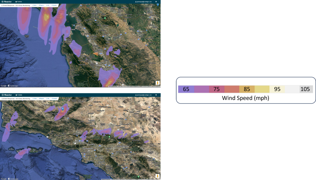
CoreLogic Weather Verification Captures Hurricane-Force Gusts
In addition to heavy and intense rainfall, weather observation stations in the San Francisco Bay Area recorded hurricane-force wind gusts, which are capable of light to moderate property damage and severe infrastructure disruption, including widespread power outages.
More than 900,000 California power customers experienced outages as the heavy rain and intense winds battered the state. CoreLogic® Weather Verification Services (WVS) and the Reactor™ Platform captured the location of the strongest winds (Figure 2).
What is a Pineapple Express? What Are Atmospheric Rivers?
Atmospheric rivers transport moisture from the tropics to the mid-latitudes in long, narrow bands of water vapor. They account for most of the horizontal moisture transport in the atmosphere and can produce heavy rainfall and snowfall when they collide with landmasses.
Atmospheric rivers are typically 250 to 375 miles wide and 1,250 to 1,875 miles long and can carry a quantity of water equivalent to 15 Mississippi Rivers. These systems occur in both hemispheres and in all seasons, but they are more frequent and intense in the winter.
The Pineapple Express is one of the most well-known atmospheric rivers. It originates near Hawaii in the tropical Pacific Ocean and affects the West Coast of North America, especially California. Warm and moist air masses associated with the Pineapple Express can bring torrential rain and strong winds to the West Coast, sometimes causing floods, landslides, and mudslides. The Pineapple Express can also enhance the snowpack in the Sierra Nevada mountains, a vital source of water for California.
Some historical examples of atmospheric river flooding in the U.S. include:
- The Great Flood of 1862 submerged much of California’s Central Valley and turned it into an inland sea for several months.
- The Columbus Day Storm of 1962, the strongest extratropical cyclone on record in the Pacific Northwest, caused widespread damage and power outages.
- The New Year’s Day Flood of 1997 affected California, Nevada, and Oregon, causing more than $1 billion in damages and 17 deaths.
- The December 2007 Pacific Northwest storms brought record-breaking rainfall and wind gusts to Washington, Oregon, and northern California, triggering widespread flooding and landslides.
- The multiple rounds of atmospheric river-induced flooding in California in 2023 when flood waters breached the levee in Pajaro, California putting thousands of homes at risk.
CoreLogic Hazard HQ Command Central will continue to watch the atmospheric river flooding in California. More information may be provided if other data becomes available. Email HazardRisk@corelogic.com with questions about the atmospheric rivers, CoreLogic Flash Flood Risk Score, the Reactor platform or any CoreLogic event response notifications.
Schneyer is CoreLogic’s director of catastrophe response.
Was this article valuable?
Here are more articles you may enjoy.
 Scientists Affirm Climate Change Fuels Extreme Weather
  New York, California Sizzle as Extreme Heat Strains Power Grids
  What Home Age Actually Tells Us About Claims — And What It Doesn’t
  Former Pro Soccer Players Show Brain Changes But No Cognitive Decline
Want to stay up to date?
Get the latest insurance news
sent straight to your inbox.