
Yet another tropical storm has blossomed in the Pacific south of Manzanillo, Mexico, while in the Atlantic the danger is fading, at least for the energy- producing areas of the Gulf of Mexico.
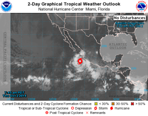
Storm Simon developed today about 135 miles (220 kilometers) off the southwestern Mexico coast, according to the U.S. National Hurricane Center in Miami. The warm water in the area provided the fuel for four storms to grow into hurricanes in September.
Mark Paquette, a meteorologist at AccuWeather Inc. in State College, Pennsylvania, predicts the same for Simon.
“I don’t see anything different from this one to the previous ones, so I expect it to behave pretty similarly,” he said in an interview yesterday.
The eastern Pacific has produced 17 storms this year, two more than average, including Hurricane Odile, which ravaged Baja California Sur, and Iselle and Julio, which threatened Hawaii earlier in the season.
In 1992, an all-time high of 24 storms developed in the eastern Pacific, where the season runs from May 15 to Nov. 30, said Dennis Feltgen, spokesman for the hurricane center. Reliable records only go back to the 1960s, when satellites began watching the seas, he said.
Quiet Atlantic
While the eastern Pacific chugs along unabated, the Atlantic has produced only five named storms, or 43 percent of the 30-year average, the center said. The basin is about to enter the period when changing weather across the U.S. begins to alter the ocean’s patterns.
“We haven’t seen a major hurricane in the production area beyond the first week of October,” said Matt Rogers, president of Commodity Weather Group LLC in Bethesda, Maryland. “There have been threats beyond this week, but they haven’t ever materialized.
My view is that the season is essentially over, as far as the Gulf goes.”
Tropical systems are classified according to the speeds of their cyclonic winds. A major hurricane is one with winds of 111 miles per hour or more, capable of doing serious damage to structures both at sea and on land.
The jet stream starts to become more active over the U.S. at this time of year, increasing wind shear in the Gulf that can tear storms apart, Rogers said. Cold fronts can also reach farther south.
Seasonal Rhythm
An average Atlantic hurricane season has a rhythm to it. In June, the bulk of the activity is in the Gulf of Mexico and the western Caribbean Sea. As the summer goes on, the origin point of storms starts to reach out into the Atlantic and eventually makes its way all the way across the basin to the Cape Verde Islands by September.
In October there is a little shrinkage, and then by November the most active part of the stage is the western Caribbean Sea.
The last time there were fewer than five named storms in the Atlantic was 1983, with four, Feltgen said.
It’s important to note that tropical systems have occurred in the Atlantic in every month of the year, so even though the odds are against something taking off, it could happen.
Was this article valuable?
Here are more articles you may enjoy.
 After Losing Job and Crypto, Man Falsely Claimed $1.3M From 107 Class Actions
  Apple in Early Settlement Talks With DOJ Over Antitrust Case
  Former Pro Soccer Players Show Brain Changes But No Cognitive Decline
  Insurance Woes Amid US-Iran War Stall Airlines’ Return to Dubai
Want to stay up to date?
Get the latest insurance news
sent straight to your inbox.