
Tropical Storm Andrea, the first of the 2013 Atlantic hurricane season, churned toward Florida with heavy rain and the potential for tornadoes.
The system was 160 miles (257 kilometers) west of Tampa as of 8 a.m. East Coast time, with top winds of 60 miles per hour, the National Hurricane Center said. It was moving north- northeast at 14 mph.
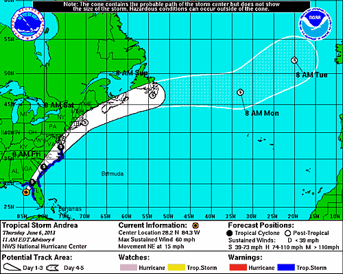
The center’s tracking map shows Andrea crossing Florida late today between Tallahassee and Jacksonville, then moving on land west of Savannah, Georgia, Charleston, South Carolina, and Norfolk, Virginia, before entering the Atlantic on a path toward Nova Scotia.
Andrea probably won’t strengthen before reaching land, and will then weaken, the center said.
Tropical storm warnings are posted for much of Florida’s western coast and for the eastern U.S. from northern Florida to southern Virginia. Tornado watches are in effect for parts of central and southern Florida.
High tides, storm surge and 3 to 6 inches (8 to 16 centimeters) of rain may bring flooding to Florida and Georgia, the center said. As much as 10 inches of rain may fall in some areas.
(Editors: Charlotte Porter, Richard Stubbe)
Was this article valuable?
Here are more articles you may enjoy.
 Apple, OpenAI Head to Court in High-Stakes AI Trade Secret Fight
  Cornell Pauses Frat Parties as Assault Case Builds Pressure
  Business Interruption Claims Are Approaching $1M Average
  Hordes of Teens on E-Bikes Force Suburbs to Rewrite Road Rules
Want to stay up to date?
Get the latest insurance news
sent straight to your inbox.