New Orleans is on edge and some offshore energy workers have been evacuated as Tropical Storm Gordon heads for the U.S. Gulf of Mexico coast. It’s expected to become a hurricane Tuesday, and threatens to spread flooding rains into the Mississippi Delta and Midwest later this week.
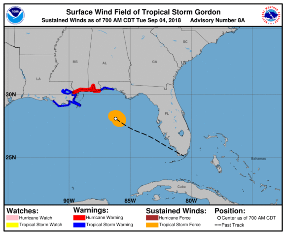
Gordon, with top winds of 65 miles (105 kilometers) per hour, was about 190 miles east-southeast of the mouth of Mississippi River, according to a National Hurricane Center advisory at 8 a.m. New York time. The center of the storm will move across the stern Gulf of Mexico Tuesday.

“Strengthening is expected today, and Gordon is forecast to be a hurricane when it makes landfall along the north-central Gulf Coast,” according to the NHC advisory. “Rapid weakening is expected after Gordon moves inland.”
On Monday, New Orleans Mayor LaToya Cantrell declared a state of emergency for the city to prepare for Gordon, according to an emailed statement from her office. She also ordered government offices to be closed on Tuesday. In 2005, a much stronger Hurricane Katrina caused flooding devastated the city, killed about 1,800 people along the Gulf Coast and left many areas uninhabitable for months.
Damage will could be as high as $500 million, said Chuck Watson, a disaster researcher at Enki Research in Savannah, Georgia.
“A significant part of the damage will be uninsured,” Watson said. “So this is a non-event from an insurance industry perspective.”
Storm Surge
A hurricane warning has been posted for the Gulf Coast from eastern Louisiana to the Florida-Alabama state line. In addition, a tropical storm warning covers other parts of eastern Louisiana to Morgan City and parts of northwestern Florida. A storm surge watch is in place along the coastline as Gordon could push water as much as 5 feet above ground depending on the tides.
Gordon will pass through the eastern edge of the Gulf’s offshore oil and natural gas platforms where it will probably have little impact because it isn’t that strong and will pass through the area quickly, said Matt Rogers, president of Commodity Weather Group LLC in Bethesda, Maryland.
“At this point it looks really disorganized,” Rogers said. “It has a really short fuse here. By later this evening it will be in and out.”
Crews were pulled off two platforms by the Anadarko Petroleum Corp. according to its website. The Louisiana Offshore Oil Port said it’s watching Gordon closely, but there currently are no disruptions.
The region produces about 5 percent of U.S. natural gas and 17 percent of crude oil, according to the Energy Information Administration. In addition, onshore facilities account for about 45 percent of U.S. refining capacity and 51 percent of its gas processing.
Flood Warnings
In addition to wind and storm surge, Gordon could drop as much as 8 inches (20 centimeters) of rain across Louisiana and Mississippi, with as much as 12 inches in some isolated areas. Winds could peak at 75 miles per hour.
Gordon will probably break up later in the week and its remnants could bring rain to the Great Plains, as well as the Midwest, where it won’t be much help for farmer preparing to harvest corn and soybeans, Don Keeney, senior agricultural meteorologist at Radiant Solutions.
“They do not need the rainfall right now. It’s going to be an issue for corn harvesting and beans,” Keeney said. “They are done growing so they need dry weather.”
Was this article valuable?
Here are more articles you may enjoy.
 Hormuz Ship Insurance Demand Drops as Owners Get Nervous
  US Appeals Court Revives Hundreds of Private Lawsuits Linking Tylenol to Autism
  CSU Lowers Atlantic Hurricane Forecast to ‘Well Below Normal’
  US P/C Industry Books Best Result in a Decade but Not All Lines Enjoy Success
Want to stay up to date?
Get the latest insurance news
sent straight to your inbox.