Don’t be lulled by a quiet June and July, the real Atlantic hurricane season is about to kick off.
The hurricane season runs from June 1 to the end of November. But the next six weeks — “the season within a season” — is regularly the most dangerous and active time for storms to develop in the Atlantic, said Dennis Feltgen, spokesman for the National Hurricane Center in Miami.
Only two named storms have developed in the Atlantic so far this year. Dry, dusty air from Africa’s Sahara robbed potential storms of moisture, and wind shear spurred by the El Nino climate systems ripped apart budding storms. Now, those brakes on hurricane development are gone.
The result: “A big change in the pattern over the Atlantic, going from a very lackluster quiet weather pattern to a much more active one,” said Dan Kottlowski, the lead hurricane forecaster at AccuWeather Inc. in State College, Pennsylvania. “We are thinking this season will be back-loaded.”
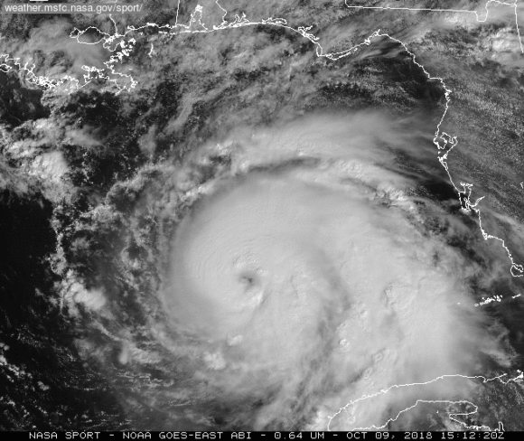
Last week, the U.S. National Weather Service forecast 10 to 17 named storms in the Atlantic. Last year, there were 15, including hurricanes Florence and Michael that killed a combined 96 people and caused more than $49 billion in damage. A storm is named when it reaches tropical storm strength, with maximum sustained winds of at least 39 miles per hour.
So far only two named storms have emerged in the Atlantic this year, and only one came during the hurricane season: Hurricane Barry, which looped through the Gulf of Mexico in July.
Fewest Since 1999
That’s the fewest named storms between June 1 and August 15 since 1999, according to Philip Klotzbach, a meteorologist at Colorado State University specializing in Atlantic basin seasonal hurricane forecasts. Subtropical Storm Andrea arrived in May, before the season’s official start.
At risk is $17 trillion in U.S. real estate along the coasts, as well as some of America’s most valuable commodities. More than 45% of U.S. refining capacity and 51% of gas processing is along the Gulf of Mexico coastline. Florida is the world’s second-largest producer of orange juice after Brazil.
There are two other factors that could spur on storms in September, according to Bob Henson, a meteorologist with Weather Underground, an IBM business.
The first is the so-called Madden-Julian Oscillation, a ripple of rising and sinking air that swirls through the atmosphere about every 45 to 60 days that can spark typhoons and hurricanes when combined with other factors. It could affect the Atlantic in late August or September, Henson said.
The second is a fast-moving atmospheric system known as a “convectively-coupled kelvin wave” that’s affected by the earth’s rotation. When one runs into a tropical wave moving off Africa, it can give it a speedy boost to swirl into a hurricane or tropical storm. There is one now moving across the Pacific on its way to the Atlantic, Henson said.
Two Calm Weeks
All of this doesn’t mean the Atlantic will pop to life at high noon on August 20. The next two weeks should extend the streak of drifting doldrums across the basin, Henson said.
Once they do start rolling, though, look out. There is a deep pool of warm water tucked into the Gulf of Mexico, across the western Caribbean and along the U.S. Southeast coastline, according to Jim Rouiller, chief meteorologist at the Energy Weather Group outside Philadelphia. Any storm that reaches those areas could explode in power, he said.
“This is high-octane fuel that is all waiting in the wings for the first storm,” Rouiller said. “This is all untapped, and it will really intensify storms.”
Was this article valuable?
Here are more articles you may enjoy.
 Scientists Affirm Climate Change Fuels Extreme Weather
  Apple in Early Settlement Talks With DOJ Over Antitrust Case
  PG&E Says Power Shutoffs Required in California on Wildfire Risk
  After Losing Job and Crypto, Man Falsely Claimed $1.3M From 107 Class Actions
Want to stay up to date?
Get the latest insurance news
sent straight to your inbox.