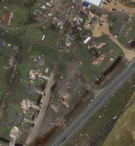
In the wake of three devastating hurricanes this season, many carriers and vendors used drones and airplanes to assess structural storm damage in several states. The use of aerial imaging combined with machine learning has led to speedier claims resolution, according to industry experts.
A recent KPMG survey of more than 300 senior insurance executives addressing the recent hurricane impact, said the two biggest challenges facing insurers, are the difficulties in assessing property damage, as well as managing customer expectations and awareness of coverage. To improve claims efficiency and communication with customers, insurance executives cited the use of drones as one of the technologies they will utilize to help quickly settle claims.
“The insurance industry has been doing a great job embracing technological innovation,” said Laura Hay, National Insurance Leader, KPMG LLP. “The recent hurricanes will present an opportunity to showcase some of the advancements made in assessing damages and rapidly settling claims.”
Nearly three-quarters of insurers placed a priority on consumer-facing technologies and connected devices, with an increasing number using drones to aid in claims property damage assessments, according to a World Insurance Report released recently by Capgemini and Efma.
Several insurers, including Travelers and Farmers, used drones to assess hurricane damage after Harvey, Irma and Maria. James Van Meter, Allianz Aviation practice leader and head of unmanned aircraft for the U.S., said that while Allianz is not actively using drones, he can see their usefulness in assessing homeowners’ claims and in mass disasters.
EagleView is just one of several companies offering aerial and drone services to property insurers. Captured footage is coupled with artificial intelligence (AI) that can analyze millions of images and data in seconds. The firm provides AI damage scores for each roof surveyed.
After reviewing Harvey images, EagleView decided to donate images to FEMA to help the agency manage its resources in finding people trapped in Houston floodwaters. In fact, aerial imagery of property damage caused by Hurricanes Harvey and Irma were also offered free of charge by Airbus Aerial and the National Insurance Crime Bureau.
Insurers aren’t the only ones to benefit from using drones to assess damage after a catastrophe. Government agencies and the private sector are also seeing the benefits of loss assessment advancements. According to a Federal Aviation Administration (FAA) press release issued last month, the Air National Guard used drones that typically performed combat operations to conduct aerial surveys to assess which disaster-stricken areas were in most need of assistance.
In addition, in order to restore electricity and air conditioning quickly, Florida Power and Light (FPL) had 49 drone teams surveying parts of the state not accessible by vehicles, sometimes within in an hour after the storm subsided, the FAA reported.
The aviation agency, which is responsible for issuing drone authorizations, reportedly issued 137 authorizations, “sometimes within a few hours, to drone operators performing search and rescue missions and assessing damage to roads, bridges and other critical infrastructure.”
FAA Administrator Michael Huerta summed up the importance of drone operations to Irma and Harvey recovery operations in a recent speech at the InterDrone conference.
“Essentially, every drone that flew meant that a traditional aircraft was not putting an additional strain on an already fragile system. I don’t think it’s an exaggeration to say that the hurricane response will be looked back upon as a landmark in the evolution of drone usage in this country,” said Huerta.
Was this article valuable?
Here are more articles you may enjoy.
 PG&E Says Power Shutoffs Required in California on Wildfire Risk
  Allianz Unit to Cut as Many as 1,800 Jobs in Push to Adopt AI
  What Home Age Actually Tells Us About Claims — And What It Doesn’t
  After Losing Job and Crypto, Man Falsely Claimed $1.3M From 107 Class Actions
Want to stay up to date?
Get the latest insurance news
sent straight to your inbox.