A new federal earthquake map dials up the shaking hazard just a bit for about half of the United States and lowers it for nearly a quarter of the nation.
The U.S. Geologic Survey updated Thursday its national seismic hazard maps for the first time since 2008, taking into account research from the devastating 2011 earthquake and tsunami off the Japanese coast and the surprise 2011 Virginia temblor.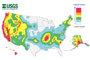
Most of the changes are slight. Project chief Mark Petersen said parts of Washington, Oregon, Utah, Oklahoma, Colorado, Wyoming and Tennessee moved into the top two hazard zones.
Parts of 16 states have the highest risk for earthquakes: Alaska, Hawaii, California, Oregon, Washington, Nevada, Utah, Idaho, Montana, Wyoming, Missouri, Arkansas, Tennessee, Illinois, Kentucky and South Carolina.
Was this article valuable?
Here are more articles you may enjoy.
 Software Firm CCC Intelligent Solutions Exploring Sale: Reuters
  US Takes Aim at Autonomous Car Mishaps in Safety Rulemaking Push
  OpenAI’s Altman to Brief US Officials on Next Wave of AI Models
  New York, California Sizzle as Extreme Heat Strains Power Grids
Want to stay up to date?
Get the latest insurance news
sent straight to your inbox.