Hurricane Sandy was the second costliest hurricane in United States history. Potvin Partners, Satellite Imaging, shows satellite imagery of Seaside Heights, N.J., before and after the destructive hurricane. The second image was taken one day after the event on Oct. 31, 2012. This service provided more than 30,000 square kilometers of post Sandy imagery for clients.
BEFORE
![US_NJ_SeasideBefore with copyright[1]](https://www.claimsjournal.com/app/uploads/2013/06/US_NJ_SeasideBefore-with-copyright1.jpg)
AFTER
![US_NJ_SeasideAfter_Oct31_with copyright[1]](https://www.claimsjournal.com/app/uploads/2013/06/US_NJ_SeasideAfter_Oct31_with-copyright1.jpg)
Was this article valuable?
Here are more articles you may enjoy.
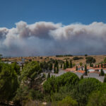 Spain and France Race to Contain Fires as Next Heat Wave Builds
  Instagram, Facebook Ran AI ‘Nudify’ Ads from China, NGO Says
 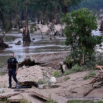 How Texas Hill Country Floods Have Tested New Warning Systems
  Ex-Red Lobster Owner Says in Lawsuit Defense That Endless Shrimp Not Its Idea
 From This Issue


Want to stay up to date?
Get the latest insurance news
sent straight to your inbox.