MEXICO CITY (AP) — Hurricane Kay steamed northward along the coast of Mexico’s Baja California Peninsula Friday and forecasters say it might bring gusty winds and two to four inches of rain to southernmost California this weekend.
Authorities in Baja opened shelters and closed schools ahead of Kay, which had maximum sustained winds of 85 mph (140 kph). As of Friday morning, Kay’s maximum sustained winds dropped to 50 mph after the hurricane skirted across the shore of Baja and moved into cooler waters, the U.S. National Hurricane Center in Miami said.
Forecasters said there is a chance the outer bands of the big storm could bring heavy rain — and possibly flash floods — to parts of scorched Southern California and southwestern Arizona tonight and Saturday.
The Hurricane Center said Kay was centered about 165 miles south of San Diego at 8 a.m. PDT on Friday. Kay was moving north-northwest, up and just offshore from the Baja coast, at 13 mph (24 kph).
Tropical storms are rare in Southern California, according to Yale University’s Climate Connections blog. Only seven tropical cyclones or their remnants have brought gale-force winds to the state. The Pacific waters off the coast of Southern California and far northern Baja California are too cool to sustain a tropical storm or hurricane for very long, because of the cold waters of the southward-flowing California Current, the blog post says. Most tropical cyclones from the northeast Pacific veer westward as they they reach the latitudes of San Diego or Los Angeles. Only two systems are known to have brought tropical storm conditions to the coast of Southern California.
Heavy rain fell on Los Cabos at the southern tip of the peninsula on Thursday. Mayor Oscar Leggs Castro said Wednesday there were more than 800 people in shelters in the twin resort destinations.
Nonessential businesses were closed and some airlines cancelled flights.
Landslides reportedly cut some roadways on the peninsula, but there were no reports of injuries.
The mayor of the town of Mulege on the Gulf of California said Thursday morning that her town had been without water since Wednesday and requested that the state send tankers.
Meanwhile, Hurricane Earl churned through open waters in the Atlantic Ocean and was forecast to pass just southeast of Bermuda on Thursday night as a major Category 3 storm.
The island’s national security minister, Michael Weeks, told reporters that public services and government offices would keep operating but warned residents to brace for tropical storm conditions.
“Bermuda will certainly feel the effects from Earl, so we must guard against complacency,” he said.
Earl was centered about 230 miles (365 kilometers) south of Bermuda early Thursday. Its maximum sustained winds had strengthened to 105 mph (165 kph) and it was moving north-northeast at 13 mph (20 kph).
Farther east, Danielle weakened to a tropical storm far out over open waters in the Atlantic some 715 miles (1,145 kilometers) north-northwest of the Azores. It had maximum sustained winds of 65 mph (100 kph).
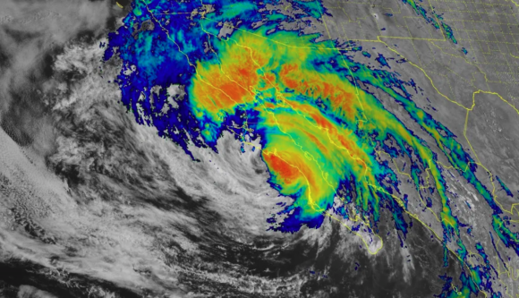
About the photo: This infrared satellite image shows Hurricane Kay off the coast of Baja California on Thursday afternoon.
Was this article valuable?
Here are more articles you may enjoy.
 Scientists Affirm Climate Change Fuels Extreme Weather
  US Hits Iran With Strikes, Blockade as Trump Plans Hormuz Charge
  PG&E Says Power Shutoffs Required in California on Wildfire Risk
  Insurance Woes Amid US-Iran War Stall Airlines’ Return to Dubai
Want to stay up to date?
Get the latest insurance news
sent straight to your inbox.