SANTA FE, N.M. (AP) — As more than 3,000 firefighters in northern New Mexico continued to battle the nation’s largest active wildfire Sunday, federal forest officials worried about future flash floods, landslides and destructive ash from the burn scar.
The 7-week-old fire, the largest in New Mexico history, remained 50% contained after charring 492 square miles (1,274 square kilometers) in rugged terrain east of Santa Fe.
Two planned burns merged to form the massive blaze at the southern tip of the Rocky Mountains in the Sangre de Cristo range.
One of the fires was previously traced to April 6, when a planned burn set by U.S. Forest Service firefighters to clear out small trees and brush was declared out of control.
On Friday, investigators said they tracked the source of the second fire to the remnants of a planned January burn that lay dormant through several snowstorms only to flare up again last month.
Firefighting costs already surpass $132 million, climbing by $5 million a day, according to authorities.
New Mexico Gov. Michelle Lujan Grisham already has asked President Joe Biden to direct the Federal Emergency Management Administration to pay for all costs related to a broad range of recovery efforts.
A Forest Service Burned Area Emergency Response team has started publishing data from its post-fire assessments.
Micah Kiesow, team leader and a soil and watershed program manager with the Santa Fe National Forest, said steep mountain slopes had acted like a sponge before the fire.
“Post-fire in some of these areas, especially the high soil burn severity areas and the moderate, we’re looking at now a steep slope that’s more like a parking lot,” Kiesow told the Santa Fe New Mexican.
He said that could signal an “extreme change in watershed response” during monsoon season.
Flooding presents another problem for communities near burn scars with ash flowing into rivers and streams, according to Kiesow.
Many water treatment facilities aren’t equipped for the expensive, time-intensive process of filtering ash. Experts say ash and debris can harm water quality with high levels of nitrates and phosphorus.
A hazard assessment from the Forest Service and U.S. Geological Survey shows that some burned areas on the New Mexico fire could see heavy debris flows if they receive about .25 inches of rain in 15 minutes.
Meanwhile, firefighters were hoping to make continued progress on the fire before the possible return of drier and warmer weather with stronger winds through Monday.
“This fire has a lot of potential left in it,” said Carl Schwope, incident commander for the southwest fire management team that has been fighting the wildfire for the past 52 days.
Initial estimates show the fire has destroyed at least 330 homes, but state officials expect the number of homes and other structures that have burned to rise to more than 1,000 as more assessments are done.
Elsewhere, 150 firefighters continued to battle a wind-driven fire that has burned more than 8 1/2 square miles (22 square kilometers) of grass, brush and salt cedar at the Arizona-California border.
The fire began Thursday on the Colorado River Indian Reservation 14 miles (24 kilometers) southwest of Parker, Arizona.
Wind gusts of up to 30 mph (48 kph) forced the evacuations of 15 homes on both sides of the river Saturday and pushed the 44% containment figure back to 34%.
However, fire officials said the evacuees likely would be allowed to return home by Sunday evening. The cause of the wildfire remained under investigation.
In Colorado, air tankers and helicopters were helping fight a new wildfire burning in the southern part of the state Sunday, the U.S. Forest Service said.
The fire, 18 miles (29 kilometers) west of Antonito, was reported Saturday in a small subdivision along the Conejos River and forced the evacuation of under 100 people north of Colorado 17, said Gregg Goodland, a spokesperson for the Forest Service’s Rio Grande National Forest.
The fire was estimated to have spread to 197 acres (80 hectares) by Saturday evening and did not grow significantly overnight, he said.
People spending Memorial Day weekend at a campground near the fire were told to be prepared to evacuate, he said.
The fire started on private property but was mainly burning on Forest Service land in a steep canyon in a variety of conifer trees along with brush and aspen north of the highway, he said. The cause is under investigation.
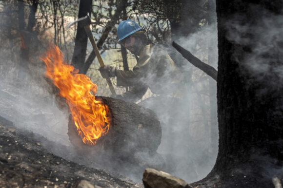
About the photo: Carson Hot Shots Tyler Freeman works to keep a burning log from rolling down a slope, Monday, May 23, 2022, as he and his co-workers work on hot spots from the Calf Canyon/Hermits Peak Fire in the Carson National Forest west of Chacon, N.M. Crews in northern New Mexico have cut and cleared containment lines around nearly half of the perimeter of the nation’s largest active wildfire while bracing for a return of weather conditions that might fan flames and send embers aloft. (Eddie Moore/The Albuquerque Journal via AP)
Was this article valuable?
Here are more articles you may enjoy.
 US P/C Industry Books Best Result in a Decade but Not All Lines Enjoy Success
  Clash of Florida Titans Pits Powerful Tribe Against Homebuilder Lennar
  CSU Lowers Atlantic Hurricane Forecast to ‘Well Below Normal’
  US Takes Aim at Autonomous Car Mishaps in Safety Rulemaking Push
Want to stay up to date?
Get the latest insurance news
sent straight to your inbox.