The colored lines spanning a graph on Mesa County surveyor Frank Kochevar’s computer screen are flat. Unlike in an intensive care unit, this is good news.
The lines remotely show Kochevar and other landslide watchers that the massive and deadly rock avalanche that roared down a Grand Mesa cliff near Collbran, Colo., on May 25 isn’t going anywhere, for now.
Measurements from sensors on what is now being termed a “debris avalanche” update every second. The scatter plots and displacement charts show whether points on the nearly 3-mile-long slide move as much as the size of a dime.
If the slide area moves more than 2 inches, an alarm tone will sound on cellphones and a text message will explain why. If it moves 4 inches or more, a different alert will notify the county’s emergency-management forces that it’s time to take action.
“It’s still a living, breathing monster,” Kochevar said of one of the largest rock avalanches ever recorded.
There are still a handful of experts climbing onto the rubble to complete mapping and workers to cut a new stream channel, but most of the attention on that epic event now is directed at computer screens.
“This is really a monitoring show at this point, “said Bill Edwards, chief ranger of the Grand Mesa, Uncompahgre and Gunnison national forests.
The Forest Service is one of the half-dozen agencies watching the monitoring system, which has roots in a nearly 20-year-old county surveying program linked to a satellite 12,000 miles in space. It has been used in the county to track deposits in a landfill as well as solve a murder.
Because the system was in place, Mesa County was able to more quickly create a monitoring program for the slide.
“No one has done this before,” said Mesa County senior engineer Tim Hayashi, who serves as “field commander” for the continuing slide monitoring and response effort.
The long-distance watchfulness is the legacy of a slide that took state and federal geologists by surprise with its speed and size.
Rock and debris had been sloughing off the flat top of the mesa for eons. But this massive drop had such power in its pulses of house-sized boulders and pulverized rock that it climbed over a ridge and overtook and killed three local men who had gone to that vantage point to see what was happening on a mountain they thought they knew well.
Nearly three months on, every inch of the slide has been examined from drone, helicopter and fixed-wing airplanes. Its depths have been peered into with a laser-signal system called Light Detection and Ranging. It has been walked by experts.
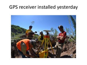
Five Global Positioning System monitors have been placed on the slide: The last one was installed last week. Two cameras record the grayish wasteland slopes at all times. One stream gauge and two rain gauges keep track of water levels, most notably from recent drenching rains that failed to move the mass.
A pressure transducer keeps tabs on what is still the most iffy and dangerous part of the slide – the humongous slab of rock and debris that fell from the cliffside and lodged near the top.
That tipped slab dammed up a depression where a pond formed and where rock still falling from the top of the cliff into the water is creating what Colorado Geological Society senior geologist Jonathan White calls “mini tsunamis.”
“That block of tilted material is still the unknown. Could it blow out? We don’t know,” White said, confirming the need for continuous close monitoring.
A team from the U.S. Forest Service will be up on the slump in the coming weeks, cutting a notch through two small berms with picks and shovels. The idea is that the notch will serve as a channel for runoff next spring or for an overflowing pond.
White said an initial report should be complete in early September, and a longer “white paper” will follow. The mapping reports will help scientists better understand and be able to gauge the potential for future debris avalanches.
Through all that activity, Kochevar watches monitors from his cubicle on a daily basis. A large model of the county landfill parked on a table outside the cubicle serves as a reminder of how Mesa County’s satellite-linked survey system has been helpful in the past.
Kochevar used the system in the early 2000s to show investigators where to look for the body of Jennifer Blagg in the landfill. He based it on GPS tracking information that could pinpoint where certain loads of trash had been dumped. The model was used to show jurors how that was possible, and Blagg’s husband, Michael, was convicted of her murder.
Now, Kochevar said, he is looking at the monitoring system as a lifesaver.
He was friends with slide victim Clancy Nichols and knew his son, Danny, who was also killed in the slide, along with Wes Hawkins.
“That’s the driving force – doing it for them,” Kochevar said. “And taking care of all those other people. We are doing everything we can to avoid another tragedy.”
Was this article valuable?
Here are more articles you may enjoy.
 Taco Bell Offers $1 Lettuce-Free Enchirito to Win Back Customers Post-Parasite
  US Takes Aim at Autonomous Car Mishaps in Safety Rulemaking Push
  Insurer Interest in AI Exclusions Growing as Risk Becomes Omnipresent
Want to stay up to date?
Get the latest insurance news
sent straight to your inbox.