All eyes are on the Rim fire in California, yet for the fifth time in 10 years, our nation is at Preparedness Level 5, which means our firefighting capabilities are stretched thin and the government can opt to bring in the military and even firefighters from other countries.
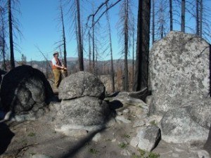
Professor Mark Cochrane, a senior scientist at the Geospatial Sciences Center of Excellence at South Dakota State University, is using satellite imagery to help improve forest management techniques. One of his projects is designed to determine which management techniques, including thinning and prescribed burns, work best in which forests in the United States. The study focuses on 630 large wildfires that occurred in the last decade in U.S. National Forests.
“Looking at how these fire regimes change as a function of climate,” Cochrane predicts “these types of fire will get worse over time.”
Source: South Dakota State University
Was this article valuable?
Here are more articles you may enjoy.
 AI’s Impact: Tech and Finance Sectors Losing 28,000 Jobs Monthly
  NYC Building Scare Shows Challenges of Converting Offices to Housing
  US Appeals Court Revives Hundreds of Private Lawsuits Linking Tylenol to Autism
  A Paint That Changes Colors When Hit. The Uses Are Striking.
Want to stay up to date?
Get the latest insurance news
sent straight to your inbox.