More than three-quarters of a million homes in the Western U.S. have a high risk of wildfire damage, according to a report released by Santa Ana, Calif.-based CoreLogic.
CoreLogic’s Wildfire Hazard Risk Report identifies more than 740,000 residences across 13 states in the Western U.S. with high levels of risk for wildfire damage. Those homes represent a combined property value of more than $136 billion.
Nearly 168,000 homes fall into the “very high risk” category, with a projected aggregated value of more than $32 billion, the report states.
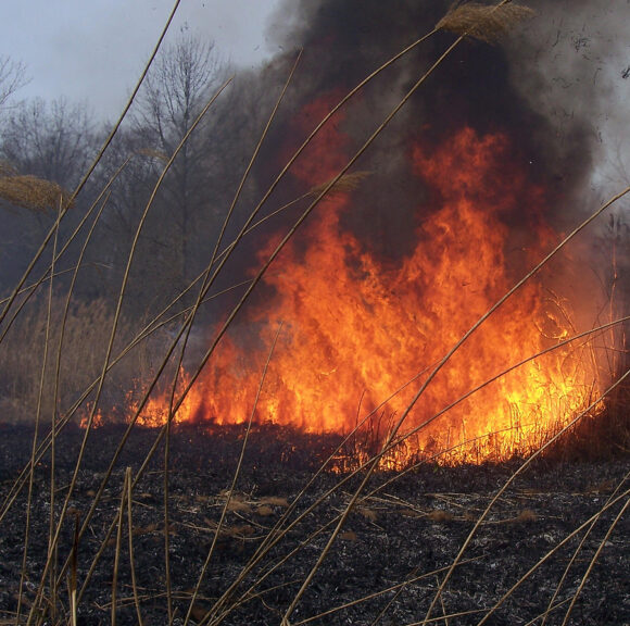
The ongoing drought and several record-setting wildfires this year put the report in an especially poignant light. Colorado and New Mexico experienced record wildfires, and some experts are predicting a severe wildfire season for California. 
California, Colorado and Texas contain the largest number of properties categorized as “very high risk” in the report.
The report assigns a numeric score ranging from 1-100 to indicate the level wildfire risk. Those levels account for risk within a property itself, as well as risk in close proximity to the property boundary. When considering the surrounding area, more than 900,000 homes in the Western U.S. can be assigned the highest wildfire risk score, considered 81 and higher. Those properties represent a combined value of more than $161 billion, the report states.
The report examines 13 western states: Arizona, California, Colorado, Idaho, Montana, Nevada, New Mexico, Oklahoma, Oregon, Texas, Utah, Wyoming and Washington. It also keys in on six cities: Los Angeles, Calif; San Diego, Calif; Boulder, Colo; Austin, Texas; Albuquerque, N.M. and Salt Lake City, Utah, as well as the top ZIP Codes at risk within each metro area.
“Over the last two decades, wildfire has been responsible for billions of dollars of property damage. Wildfires dominated news headlines in 2011, and again this summer, they have been responsible for record-setting property destruction across a swath of states spanning the West, from Colorado to Idaho to Washington,” Howard Botts, vice president and director of database development for CoreLogic Spatial Solutions, said in a statement. “In 2012, we are experiencing a high fuel load of natural vegetation combined with very dry and hot conditions to produce a record wildfire season in terms of the number and size of fires across the U.S. Even so, unlike other natural hazards, such as hurricanes, tornadoes, hail storms and earthquakes, wildfires can be extinguished or redirected through fire suppression efforts. Accurately identifying risk levels, even in areas where wildfire activity has historically been low, is imperative to mitigating the potentially devastating effect of fires to property and on human life.”
Not surprisingly the states most commonly associated with wildfires contain the most properties at risk. California, Colorado and Texas contain the largest number of properties categorized as “very high risk,” with a combined property value exceeding $20 billion. Adding the homes located in the “high risk” category increases the total property value at risk to more than $62 billion.
California contains a total of 49,258 homes at “very high risk.” Colorado has 48,901 homes considered as such, and Texas has 28,490 homes in that category.
“The total combined value of properties in California and Colorado that are located in very high risk areas exceeds $21 billion,” the report states. “Adding the homes located in the High Risk category increases the total value by more than $62 billion.”
California has 233,237 properties considered “high risk,” while Colorado has 45,311 properties considered “high risk.”
By dollar amount Colorado leads the list for “very high risk” exposure. The report shows nearly $12.5 billion in properties in that category.
The state was plagued with wildfires over the summer, with two of the most expensive wildfires in state history striking one after the other. The two most destructive wildfires in Colorado’s history will cost insurers roughly $450 million, according to a regional insurer association. The massive figure for insured losses comes from the total 600 homes destroyed and other damages by the two fires, which raged in June and July.
There is nearly $9.5 billion worth of exposure in California in the “very high risk” category, according to the report.
There are 195,149 residences in Texas in the “high risk” category, and 28,490 in the “very high risk” category, the report shows. New Mexico (9,732), Oregon (9,291), Montana (7,668) and Arizona (7,637) are other western states with a large number of “very high risk” properties.
Of the six cities analyzed in the report, Los Angeles is home to the most single-family residences exposed to wildfire risk, with more than 29,000 properties in the “high” or “very high risk” categories.
The total value of the homes in the two categories combined is estimated to be nearly $10 billion, with Malibu at the top of the list of ZIP Code areas with more than $900 million in potential residential property exposure to wildfire risk, according to the report. Beverly Hills ($578 million), Los Angeles ($447 million) and Topanga ($361 million) were other Los Angeles area cities at the top of the list.
San Diego’s exposure for “very high risk” properties is $284 million, and $2.7 billion for “high risk” properties, the report states.
For Colorado Bolder tops the list for exposure with $1.8 billion in the “very high risk” category and $462 million in the “high risk” category. Austin tops the list in Texas with $232 million in the “very high risk” category and $4.8 billion in the “high risk” category.
A portion of the report includes a Wildland Urban Interface, which identifies the intersection of potentially high-risk fire areas and large numbers of homes. The report states that just between the years of 1990 to 2008, there were nearly 17 million new homes built in the U.S., of which 10 million were located in the WUI and therefore potentially located near high wildfire risk zones.
The report was developed to provide the insurance industry, financial services companies, homeowners and others impacted by wildfire outbreaks with a better understanding of wildfire risk in the U.S.
Was this article valuable?
Here are more articles you may enjoy.
 Ex-NFL Player’s Parents Allege Excessive Police Force Led to His Wrongful Death
  Hormuz Ship Insurance Demand Drops as Owners Get Nervous
  A Super Yacht Armada Came to Miami, Leaving a Marine Graveyard in Its Wake
Want to stay up to date?
Get the latest insurance news
sent straight to your inbox.