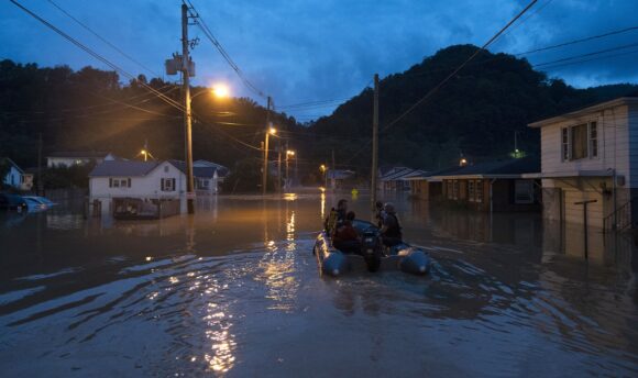
Kentucky’s death toll from record flooding has risen to 16 people and many more are missing as incessant rain inundates homes, washes away roads and forces residents to seek shelter on rooftops.
“We have 16 confirmed fatalities, and folks that is going to get a lot higher,” Kentucky Governor Andy Beshear said Friday in a briefing.
As many as 28 roads in eastern Kentucky have been closed by debris, and officials are worried the Panbowl Lake Dam near Jackson could breach, Beshear said. More than 23,000 homes and businesses across the state are without power, and in some areas natural gas service has been cut and mobile phone service is down.
President Joe Biden has approved disaster funds for the state, which seven months earlier suffered from the worst tornado strike in Kentucky’s history.
Torrential rains have swept across the central US, setting records earlier this week in Missouri and causing destructive flooding in mountainous areas of eastern Kentucky and West Virginia. The floods have left many residents trapped as roads have been washed away. Sixteen shelters have been set up and at least two state parks have been opened for residents.
Last December, more than 75 people were killed and hundreds were hurt when a powerful tornado ripped across western Kentucky. Many Federal Emergency Management Agency crews on hand to help recovery efforts from the tornado are now shifting to deal with the floods.
“Governor, my heart aches for you going through so much tragedy again so soon,” FEMA Administrator Deanne Criswell said at the briefing. The agency is sending additional search-and-rescue teams to hunt for missing residents.
In neighboring West Virginia, Governor Jim Justice declared a state of emergency in six counties across the state due to the same heavy rains. National Guard units from West Virginia and Tennessee have arrived to help with search-and-rescue operations. At least 294 people have been plucked from flood waters so far, with as many as 100 taken by air
While the rain will taper off Friday, rivers and streams are still struggling with the deluge and it is likely heavy downpours will return next week, said Zach Taylor, a senior branch forecaster at the US Weather Prediction Center.
“We are still looking a pretty serious situation across eastern Kentucky,” Taylor said. “Unfortunately there will be additional heavy rainfall going into Sunday and Monday.”
The North Fork Kentucky River in Jackson jumped 37.5 feet (11.4 meters) in under 33 hours as rains came down, according to the National Weather Service.
More than 7.25 inches of rain has fallen in Jackson so far this week, setting records for the dates on Tuesday, Wednesday and Thursday. Taylor said 9 to 10 inches of rain fell across a narrow band of Kentucky through the week.
There may be a little more as a frontal boundary moves south through the area. That boundary will rebound, bringing more heavy rain to start next week.
“It looks like it is going to rain a lot on Monday and Tuesday,” Beshear said.
Was this article valuable?
Here are more articles you may enjoy.
 US Hits Iran With Strikes, Blockade as Trump Plans Hormuz Charge
  Scientists Affirm Climate Change Fuels Extreme Weather
  Citadel Securities Asks to Join Susquehanna Insider-Trading Suit
  New York, California Sizzle as Extreme Heat Strains Power Grids
Want to stay up to date?
Get the latest insurance news
sent straight to your inbox.