Tropical Storm Michael, on the verge of becoming a hurricane, is chugging toward the Florida panhandle on a path that may miss Gulf of Mexico oil platforms, but will bring driving rain and high winds to the region’s agricultural and tourism industry.
The storm is about 90 miles (145 kilometers) east of Cozumel, Mexico, and is forecast to become a hurricane today, with winds eventually near or at major hurricane levels, the U.S. National Hurricane Center said in its latest advisory. That could mean at least 111 miles per hour (179 kilometers per hour).
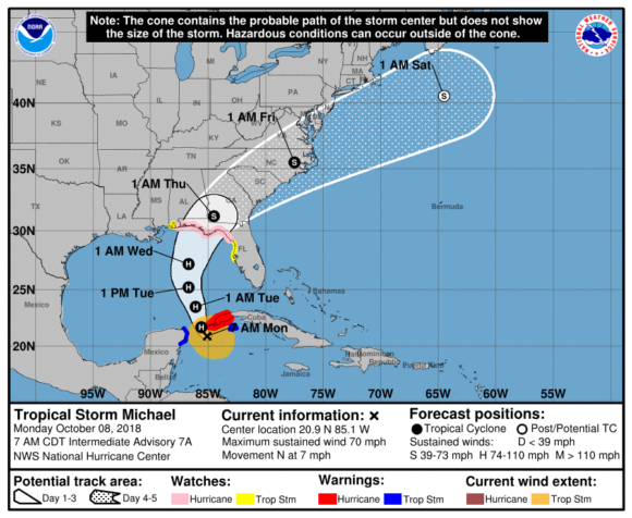
Traveling north at about 7 miles per hour, Michael is now sustaining maximum winds of 70 miles per hour, the center said. On Sunday, Florida Governor Rick Scott declared a state of emergency in 26 counties. While the state’s Panhandle is more sparsely populated than many other areas, it includes the capital city of Tallahassee, Pensacola and Panama City.
“This storm will be life threatening and extremely dangerous,” Scott said. “Everybody’s got to get ready.”
While most citrus in Florida is produced in the lower two-thirds of the peninsula, south of the storm’s path, heavy rain could create difficulties for the U.S. Southeast cotton harvest. Georgia had collected 6 percent of its crop as of Sept. 30 and Alabama had reaped 5 percent, U.S. Department of Agriculture data show.
Matt Rogers, president of the Commodity Weather Group LLC, said in an interview early Monday that there’s only a 10 percent chance of damage to oil and gas platforms.
“The worst part of the storm should be on the east side,” he said. “It should stay clear of the production zone.”
Still, Michael could affect energy in the region by lowering demand for power, and thus natural gas, Rogers said, noting, “instead of being in the upper 80s, it’ll be in the 70s” Fahrenheit.
After making landfall in the Panhandle region, the storm is forecast to bend back across Georgia, North Carolina and South Carolina later in the week.
On the current forecast track, the center of Michael will move over the Yucatan Channel on Monday, then across the eastern Gulf of Mexico late Monday through Wednesday, according to the National Hurricane Center.
“It’s a fast-mover,” Rogers said in the interview. “It’s an in-and-out type of deal.”
It’s common to see big “monsoon-like” systems develop in Central America at this time of year, said Jeff Masters, co-founder of Weather Underground. As of Thursday, the Atlantic had produced 12 named storms this season. They include Hurricane Florence, the most powerful one so far this year.
The panhandle region has suffered storm damage in the past, hit by Hurricane Ivan in 2004 and Hurricane Dennis in 2005. In 2010, the Deepwater Horizon oil spill hit Pensacola Beach, hurting the fishing and tourism industries.
The area is also home to a number of military bases, including the Naval Air Station at Pensacola and Eglin Air Force Base.
Was this article valuable?
Here are more articles you may enjoy.
 US Considers Creating Finra-Like Watchdog to Vet Top AI Models
  US Takes Aim at Autonomous Car Mishaps in Safety Rulemaking Push
  US Hits Iran With Strikes, Blockade as Trump Plans Hormuz Charge
  Citadel Securities Asks to Join Susquehanna Insider-Trading Suit
Want to stay up to date?
Get the latest insurance news
sent straight to your inbox.