A Caribbean disturbance with the potential to disrupt Gulf of Mexico energy operations crossed the Yucatan Peninsula today as Tropical Storm Erin moved westward across the Atlantic.
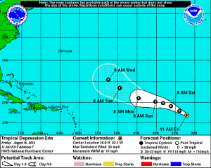
Erin, 430 miles (695 kilometers) west of the Cape Verde Islands, headed west-northwest at 16 miles per hour, the National Hurricane Center said in a 5 a.m. New York time advisory. The storm, with winds of 40 mph, may strengthen to 60 mph in two days as its forward speed slows.
The hurricane center is also tracking a tropical wave over Mexico’s Yucatan, home to beach resorts, that has a 50 percent chance of developing into a cyclone in the next two days.
“There is potential for development once the disturbance moves over the Gulf of Mexico later today,” the center said in a separate advisory.
The Gulf is home to about 6 percent of U.S. natural gas output, 23 percent of oil production and at least 45 percent of petroleum-refining capacity, according to the U.S. Energy Department.
The Bay of Campeche, at the southern end of the Gulf, is where Petroleos Mexicanos, Mexico’s state-owned oil company, has most of its output. Florida is the second-largest producer of oranges after Brazil.
Land Threat
Erin will have “no impact to land for the foreseeable future” and poses little threat to the U.S., said Andy Mussoline, a meteorologist at AccuWeather Inc. in State College, Pennsylvania.
Atlantic storms are followed closely by energy companies and commodities traders because they can disrupt production and processing of natural gas and oil and destroy crops.
Erin is the fifth storm of the Atlantic season, which runs from June 1 to Nov. 30. It’s forecast to encounter dry air farther west and there’s a chance it will fall apart about five days east of the Lesser Antilles, the center said yesterday.
The Caribbean system bears watching as it may strengthen once it reaches the southern Gulf, said Matt Rogers, president of Commodity Weather Group LLC in Bethesda, Maryland.
Some computer models show the system gaining enough strength to become a tropical storm before going ashore for a last time anywhere from Mexico to Louisiana, Rogers said. Two of the most reliable models predict it won’t develop.
‘Critical’ Period
“The next 12 to 24 hours will be critical to see what we have left of this wave as it crosses the Yucatan,” Mussoline said. Whether it develops, “the potential is there for heavy flooding rainfall to affect the central Gulf Coast this weekend.”
Enbridge Inc.’s Manta Ray offshore natural gas gathering company evacuated non-essential personnel from two platforms off Louisiana on Aug. 14. Marathon Oil Corp. evacuated some workers from its Ewing Bank platform in the Gulf yesterday.
BP Plc began removing non-essential personnel from four offshore platforms yesterday, and drilling rigs contracted by the company halted operations. Production at all platforms “remains online,” the company said in a website statement.
(With assistance from Christine Buurma and Adam Cataldo in New York and Lananh Nguyen in London. Editors: Randall Hackley, Tony Barrett)
Was this article valuable?
Here are more articles you may enjoy.
 Scientists Affirm Climate Change Fuels Extreme Weather
  Clash of Florida Titans Pits Powerful Tribe Against Homebuilder Lennar
  What Home Age Actually Tells Us About Claims — And What It Doesn’t
  US Takes Aim at Autonomous Car Mishaps in Safety Rulemaking Push
Want to stay up to date?
Get the latest insurance news
sent straight to your inbox.