ZACHARY, La. (AP) — You can’t quite see it yet from Plank Road or La. 19 near Zachary, but work crews are building a man-made river from scratch.
Down inside a huge, wide “V” carved out of the earth, concrete pillars for a bridge have been poured and smoothed out by workers. Nearby, long-reach excavators placed big boulders along the sides of a channel, while other digging machines clawed up dirt and dumped it into trucks that hauled it away.
After decades of delays, political wrangling, and cobbling together around $580 million, the long-awaited Comite River Diversion Canal is finally becoming a reality.
The U.S Army Corps of Engineers and the state Department of Transportation and Development have broken up construction of the Comite River Diversion Canal into a series of phases, or segments, that can be built somewhat independently of one another in case one area runs into delays. Some of those areas, including Segment 3, have hit problems because of delays in the negotiation of interstate gas pipelines owned by Florida Gas.
Critics of the flood-fighting project’s 40-year-long slog towards construction have derisively called it a “boondoggle” and just a “drainage ditch.” But contractors working for the Corps of Engineers are clearly building something much bigger than a ditch.
It’s a whole new body of water.
When the canal opens — in 2024 or 2025, officials hope — a diversion structure will continuously redirect the Comite River once it rises above a certain height. Those higher water levels, experts say, often contribute to flooding downstream, where hundreds of thousands of people live.
The excess water will be turned west away from the Amite River, where it normally flows, and go down the new canal to the Mississippi River north of Baton Rouge.
The new waterway is being carved from what was once solid earth. It will be able to funnel the equivalent of the Arkansas River, reducing flooding in the middle Amite basin, according to Corps of Engineers’ estimates.
To accomplish that goal, this straight, rock-lined waterway will need everything in its 12-mile path to either get out of its way, go over its banks, or slide underneath its bottom. That includes roads, railroads, pipelines, wetlands and private properties, according to Corps of Engineers plans.
The landscape will change so much that seven new bridges will be required. They include the one contractors are building near McHugh Road and more to the west, at U.S. 61 and the Kansas City Southern Railroad.
Patrice Maguire, 53, lives just north of the McHugh Road bridge construction zone with her husband, Chris, 55. They’ve heard the dirt equipment in the distance from the woods behind their house, and they’ve seen the trucks passing in front of their home.
Right now, only mounds of fresh dirt and the tops of cranes and construction equipment are visible from Plank Road. But Maguire said she knew all that work would eventually come, if the canal was going to reach the Comite River east from her home.
“Every time I pass there and see what they’re doing, I’m wondering, `Are they going under this road? What’s going to happen to Plank Road?”’ she said.
Maguire had heard about the project. But had not understood that extending the canal to the Comite meant a new lengthy bridge would have to be built for Plank Road across what today is solid ground.
“Wow, that’s a lot of money,” Maguire said.
Plank Road and La. 19, which the state Department of Transportation and Development contractors will handle, are the next dig-and-bridge projects set for construction later this year, Corps and DOTD officials said.
A short piece of unexcavated canal near the McHugh site shows just how much earth-moving is happening. It is almost as long as a football field across the top and goes down below the surface an estimated 42 feet.
Corps officials estimate the entire project will require the removal of nearly 9.2 million cubic yards of earth, enough to fill the Caesars Superdome in New Orleans just about twice. A chorus of dump trucks is piling that material into large spoil banks lining each side of the canal; they have removed 1.68 million cubic yards so far.
One of the most dramatic alternations to the landscape for the diversion is still to come: three local bayous will be completely redirected into the canal.
Though the diversion of the Comite River provides about 70% of the flood reduction benefit from the Comite Diversion, Bobby Duplantier, a Corps senior project manager, said shifting the flow of the bayous will also make a big difference.
“That’s really going to provide … a lot of benefit to those neighborhoods in smaller events, you know, those events when you get a lot of nuisance flooding,” Duplantier said.
Estimates from at least two decades ago _ the latest available, though new estimates are coming _ suggest the diversion’s strongest benefit will be in the Zachary and Baker areas, where upwards of a 6-foot drop in water levels during a 100-year flood are projected. The bayous will also keep some water in the diversion canal when the Comite is too low to be diverted. But the public benefit comes with a permanent price.
The channel will cut the White, Baton Rouge and Cypress bayous in half. Their water north of the canal will be permanently rerouted, Corps plans say.
Manmade electric pumps will draw water up from the future diversion canal and dump it back into the bayous to keep water flowing in them below the canal. The diversion will remain a permanent barrier to aquatic wildlife, however.
East Baton Rouge Parish, under a prior agreement with the Corps, will have to keep those pumps running for the wildlife, along with most other long-term maintenance costs like debris removal, Corps officials said. Parish officials said they and Corps are still working out what the canal’s full costs will be.
Corps plans had originally called for costly concrete structures that would have sent the bayou waters spraying over 25-foot waterfalls down into the canal, Duplantier explained.
But Corps officials met with counterparts in Mississippi, where a less dramatic and less costly option was already being used.
So-called “rock chutes” will slow down the bayou waters for 1,200 to 1,500 feet upstream, gradually easing the transition and funneling water down into the diversion canal’s bottom. The chutes will gradually widen as the bayous approach the canal.
In addition to cutting about $25 million in costs, Duplantier said the chutes eliminated a safety concern: Dramatic waterfalls would have likely drawn curious onlookers. The diversion won’t be a public access waterway, including for fishermen and boaters.
“This is a much less intrusive kind of flow into our channel versus a big waterfall, I call it, into the channel,” Duplantier said.
The Corps of Engineers has already awarded construction contracts for two of those chutes, at White and Cypress bayous, but work is just gearing up.
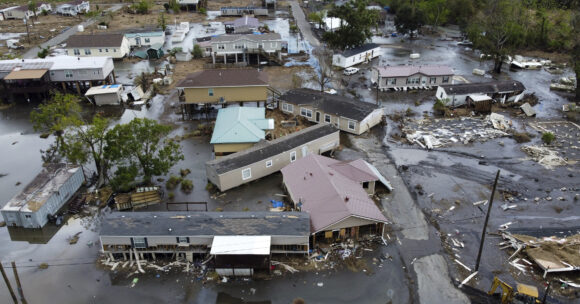
About the photo: Mud and debris surround damaged homes after Hurricane Ida in Ironton, La., on Sunday, Sept. 19, 2021. Weather extremes like this — as well as drought, wildfire, flooding and diminishing air quality will increase in frequency and intensity in North America the coming years as global warming accelerates, according to the United Nations Intergovernmental Panel on Climate Change report. (David Grunfeld/The Times-Picayune/The New Orleans Advocate via AP)
Was this article valuable?
Here are more articles you may enjoy.
 Former Pro Soccer Players Show Brain Changes But No Cognitive Decline
  US Takes Aim at Autonomous Car Mishaps in Safety Rulemaking Push
  After Losing Job and Crypto, Man Falsely Claimed $1.3M From 107 Class Actions
  New EVs From Toyota, Subaru Breathe Life into Struggling Market
Want to stay up to date?
Get the latest insurance news
sent straight to your inbox.