Decades of additional weather data have led federal officials to reconsider rainfall totals in Texas that define 100-year weather events and caution that extreme rainstorms will strike the state more frequently.
The National Oceanic and Atmospheric Administration on Thursday released a study finding that in the Houston area, for instance, 100-year estimates increased from 13 inches (33 centimeters) to 18 inches (46 centimeters) for a 24-hour period. Rainfall previously classified as 100-year events are now more frequent 25-year events.
A 100-year storm is one that, on average, occurs every 100 years, or has a 1 percent chance of happening in any given year.
In the Austin region, 100-year rainfall amounts for 24 hours increased as much as 3 inches (8 centimeters) up to 13 inches. The 3-inch increase was the same for the area just north of Corpus Christi, a portion of West Texas that includes the border county of Val Verde, and elsewhere.
“Current standards used for infrastructure design and floodplain regulations will possibly be revised based on the new values,” said Mark Glaudemans with NOAA’s Office of Water Prediction. “Officials in locations that have seen significant increases are already assessing the potential impacts of adopting the new estimates.”
Earlier rainfall estimates provided by NOAA were based on data that in some cases are more than 50 years old.
In a January report, the National Hurricane Center determined that the Houston metro area last year experienced a flood brought by Hurricane Harvey that was a greater than a once-in-1,000 year event, the highest level that’s calculated.
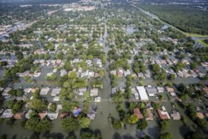
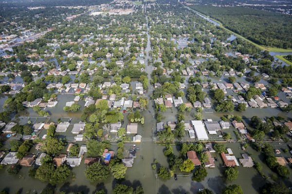
An aerial view shows extensive flooding from Harvey in a residential area in Southeast Texas, Aug. 31, 2017
Until Harvey, the record for rainfall from a hurricane or tropical storm in the Lower 48 states was 48 inches (122 centimeters) in 1978, and 52 inches (132 centimeters) in Hawaii in 1950.
With Harvey, seven places beat out the 52-inch record and 18 places beat the 48-inch mark. The top two – Nederland and Groves, Texas – both were more than 60.5 inches (154 centimeters).
The NOAA findings released Thursday can have wide-ranging implications. NOAA rainfall values guide state and federal regulations that then dictate how infrastructure design and development is done. They also determine flood risks and are used in the development of floodplains.
Harris County commissioners on Tuesday earmarked $14.5 million for updated flood plain maps in the wake of Harvey. The maps rely on rainfall data to help Houston-area regulators determine where homes can be built, insurance costs and locations for flood-control projects. It wasn’t clear Thursday how the NOAA report may affect the revision of those maps. A spokeswoman for the Harris County Flood Control District did not return a message seeking comment.
Was this article valuable?
Here are more articles you may enjoy.
 Software Firm CCC Intelligent Solutions Exploring Sale: Reuters
  After Losing Job and Crypto, Man Falsely Claimed $1.3M From 107 Class Actions
  What Home Age Actually Tells Us About Claims — And What It Doesn’t
  PG&E Says Power Shutoffs Required in California on Wildfire Risk
Want to stay up to date?
Get the latest insurance news
sent straight to your inbox.