POOLESVILLE, Md. (AP) — When environmentalist Brent Walls saw a milky-white substance in a stream flowing through a rural stretch of central Pennsylvania, he suspected the nearby rock mine was violating the law.
Recent rains had filled the ponds at the mine that allow sediment to settle out of the water, but Walls couldn’t easily take a look because they were surrounded by private property. To quickly investigate and avoid trespassing, Walls captured images of the area with his drone.
“That’s when I found the illicit discharge,” he said. The photo of cloudy liquid flowing into the creek provided evidence Walls used to accuse Specialty Granules LLC of violating the Clean Water Act.
Fifty years after that landmark legislation was signed into law, drones are giving environmentalists a new tool to capture wrongdoing where it is hard to see or expensive to find, though their use to investigate polluters is still pretty rare, Walls said.
He would like them used more often. With the help of a grant, he trains drone pilots for the Waterkeeper Alliance, a global network of clean water groups. The nonprofit wants activists from around the country to know how to use the technology for storytelling and to collect evidence that companies are polluting rivers and streams.
The Clean Water Act allows individuals — not just federal officials — to enforce the law. But citizens who want to use drones to collect evidence must have a federally-issued pilot’s certificate and navigate layers of federal, state and local rules.
Walls is the Upper Potomac Riverkeeper and part of a riverkeeper network that has used drones in a handful of other instances to collect evidence of pollution and threaten lawsuits if they aren’t satisfied with how companies respond to allegations. Drones were used, for example, to investigate a West Virginia coal operation that allegedly discharged coal residue into a nearby river. Walls said drone footage helped push the company to clean up the site.
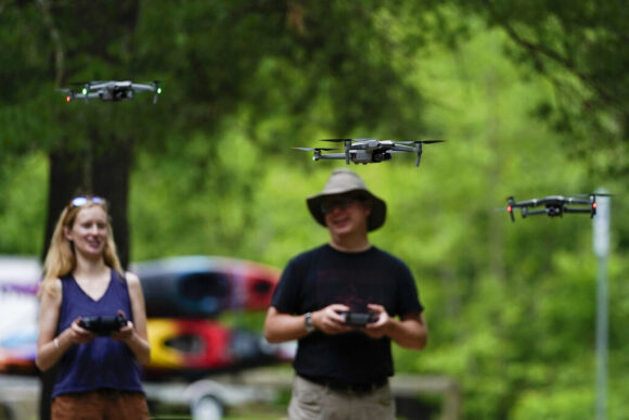
On a pleasant, lightly windy day in June, Walls held an in-person training near the fourth hole of Bretton Woods Golf Course just off the Potomac River in Maryland.
Waccamaw Riverkeeper Cara Schildtknecht from the Carolinas coast said it was awesome to be able to finally pilot the drone. “We’ve been training to do this for months,” she said at the in-person training with three other clean water advocates.
Schildtknecht had been through Walls’ online courses and passed the test for her pilot’s certificate. After she arrived, she peeled the stickers off her drone. It was her first time flying one.
Walls helped the group ensure their controllers connected properly with their drones before they each had a chance to pilot a practice flight for about 10 minutes.
Schildtknecht said a drone will help her see areas in her watershed that are hard to reach by boat, record floods and find polluters. The view from above she said “is a gamechanger,” one that previously required paying a pilot for a manned flight.
“We have certain areas that we know could be of concern that we want to check out,” she said.
Technological advances have helped grow the drone market. Miriam McNabb, editor-in-chief of the trade publication Dronelife, said drones are now easier to fly, capture better images and can be programmed to automatically conduct surveys and track changes over time.
While drone prices can vary widely, the grant-purchased drones for the newly-trained activists cost around $2,000, Walls said.
After Walls presented Specialty Granules with his allegations in 2019, the company stopped discharges through the pipe the drone had identified and installed a filtration system that improved water quality.
Matthew McClure, vice president of operations at Specialty Granules, said in a statement that the drone images helped identify the discharge of non-toxic stormwater and that the company uses drones in its own operations. But McClure didn’t welcome the surprise inspection.
“Unscheduled drone overflies can present a distraction and potential accidents to employees who operate heavy machinery,” McClure said.
The ubiquity of drones that shoot video has also triggered privacy concerns. Cam Ward, a former Alabama state senator who is now director of the Alabama Bureau of Pardons and Paroles, sponsored a bill in 2020 to curtail drone use over “critical infrastructure,” a term that included mines, refineries, pipelines and natural gas plants.
“There has to be some expectation of privacy,” he said.
A local environmental group that used a drone in Alabama to record discharges from an abandoned mine site argued the 2020 bill would prevent activists from keeping an eye on misbehaving companies.
Ward said he was concerned about environmentalists sabotaging important facilities. To keep sites safe, and to protect the privacy of business owners, he said there should be limits on drone use, although finding the right balance is “incredibly complex.” His bill did not pass.
Scientists and industry already widely deploy drones to monitor whales, count trees and inspect cell towers. But even some environmental groups are skeptical of their widespread use to investigate water pollution. Not only do pilots need to be federally-certified, but rules for drone use differ by location — the Federal Aviation Administration isn’t the only agency setting the rules.
“It is a patchwork of uneven, inconsistent, local, state and federal regulations across our region,” said DJ Gerken, program director at the the Southern Environmental Law Center that works with partners who use drones. Navigating that patchwork of rules matters for ensuring that evidence is admissible in court.
Walls said his training is meant to help people navigate the rules and pass the FAA test. He teaches how to identify restricted airspace, avoid structures and operate safely. To protect privacy, for example, pilots are told to make flight plans that avoid residential properties.
Anastasia Telesetsky, an environmental law professor at California Polytechnic State University, called drones a convenient tool for finding pollution that has been out of sight.
“There’s a lot of groups that know there is a problem but have been limited in the tools they can use to compel regulators to do their jobs,” she said.
Martin Lively is the Grand Riverkeeper in northeastern Oklahoma. A former mining site that’s bad enough to make the federal Superfund list is in his area.
“It is extremely polluted with lead, zinc, arsenic, cadmium, manganese,” he said. “And all of that flows into my watershed.”
Because of the pollution, the river is already regularly tested. But a drone goes a step further, helping determine, for example, whether cleaned up properties might be recontaminated when it floods.
He says a drone is a storytelling tool that can capture powerful images.
“That is a tool never to be underestimated in litigation,” he said.
–Phillis reported from St. Louis.
About the photo: Quincey Johnson, left, outreach director Upper Missouri Waterkeeper in Bozeman, Mont., and Martin Lively, Grand Riverkeeper with LEAD Agency in Miami, Okla., fly their drones during a training session, Tuesday, June 7, 2022, in Poolesville, Md. They work to protect rivers and waterways and are training to use drones to catch polluters in places where wrongdoing is difficult to see or expensive to find. The Waterkeeper alliance has already used drone images to formally accuse companies of wrongdoing. (AP Photo/Julio Cortez)
Was this article valuable?
Here are more articles you may enjoy.
 Software Firm CCC Intelligent Solutions Exploring Sale: Reuters
  US Takes Aim at Autonomous Car Mishaps in Safety Rulemaking Push
  CSU Lowers Atlantic Hurricane Forecast to ‘Well Below Normal’
  US Hits Iran With Strikes, Blockade as Trump Plans Hormuz Charge
Want to stay up to date?
Get the latest insurance news
sent straight to your inbox.