Tropical Storm Henri is set to grow into a hurricane before slamming the U.S. Northeast anywhere from Long Island to Massachusetts, bringing heavy rain, a flooding storm surge and thrashing winds to the region starting Sunday.
Hurricane watches have been posted along Long Island beaches, as well as from Connecticut to Massachusetts, the U.S. National Hurricane Center said in an 8 a.m advisory. Tropical storm watches — in those areas further from Henri’s center — stretch from Fire Island to East Rockaway Inlet in New York and along the Connecticut coast west of New Haven.
While New York City is west of the track, tropical-storm strength winds could whip through the five boroughs starting late Saturday and linger through the day on Sunday, the National Weather Service said.
“The combination of a dangerous storm surge and the tide will cause normally dry areas near the coast to be flooded by rising waters moving inland from shoreline,” John Cangialosi, a senior hurricane specialist at the center, wrote in his forecast. “The deepest water will occur along the immediate coast in areas of onshore winds.”
Henri will likely make landfall as a Category 1 hurricane on the five-step Saffir-Simpson scale Sunday, with winds from 80 to 85 miles per hour, the hurricane center said. It will then weaken to a tropical storm as it drives into interior New England and will likely be lingering in central Massachusetts Monday.
Winds could tear down trees, knock over signs and blow around debris, as well as damage smaller buildings across Long Island and New England, but parts of New York and New Jersey could also feel the effects, the weather service said. There is also a chance of isolated tornadoes as Henri moves over the regions.
The ocean could rise as much as 4 feet along Long Island’s shoreline and as much as 5 feet from Watch Hill, Rhode Island to Sagamore Beach on Cape Cod. In addition to the surge, 2 to 5 inches of rain will likely fall across southern New England, with some areas getting up to 8 inches.
Boston Impact
Landfall is likely near Providence, Rhode Island about 2 p.m. Sunday and then the storm will slowly track into central Massachusetts west of Boston, said Don Keeney, a meteorologist with commercial forecaster Maxar.
“That is not necessarily a good thing because the bad part of the hurricane is on its east side,” he said. “That isn’t going to bode well for Boston and Cape Cod.”
While storms in New England tend to move quickly, Henri will slow down as larger weather patterns exert their influence. It will take nearly a day and half from the time it makes landfall to when it starts to move through Maine.
“It is going to slow down considerably,” Keeney said. “It is going to have a full day and half to traverse New England. That is quite a long time.”
Hurricane Isaias ripped up the East Coast last year, knocking out power to millions in New Jersey and New York. Hurricane Irene touched off massive flooding across New England, in particular Vermont, after it roared over Manhattan heading north in 2011. The entire Northeast, especially New York and New Jersey, were devastated by Superstorm Sandy in 2012, which caused $77.4 billion in damage.
So far, eight storms have formed in the Atlantic this year, four of which hit the U.S., which usually doesn’t happen until the end of September. In addition to Henri, forecasters also are watching Hurricane Grace, which made landfall in Mexico’s Yucatan Peninsula earlier Thursday is forecast to strike the country again between Vera Cruz and Tampico overnight Friday into Saturday.
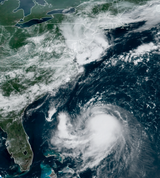
About the photo: Tropical Storm Henri is seen from a geostationary satellite over the Atlantic Ocean. Photo courtesy of the National Hurricane Center.
Was this article valuable?
Here are more articles you may enjoy.
 Snap Nears Settlement of Addiction Case Ahead of Jury Trial
  Clash of Florida Titans Pits Powerful Tribe Against Homebuilder Lennar
  US P/C Industry Books Best Result in a Decade but Not All Lines Enjoy Success
  New York, California Sizzle as Extreme Heat Strains Power Grids
Want to stay up to date?
Get the latest insurance news
sent straight to your inbox.