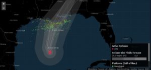
Hurricane Zeta is strengthening as it whirls across the Gulf of Mexico, threatening to slam the Louisiana coast south of New Orleans tonight with 90-mile-per-hour winds, massive power outages and floods.
It’s expected to come ashore about 7 p.m. local time as a Category 1 storm, the U.S. National Hurricane Center said in its latest forecast. Zeta, expected to cause as much as $3 billion in damages, will be the record fifth hurricane or tropical storm to hit Louisiana this year.
Earlier forecasts called for Zeta to make landfall as a Category 2 storm, with winds of 100 miles (161 kilometers) per hour. Even as a Category 1, it will still pack plenty of punch with “strong, damaging wind gusts, which could cause tree damage and power outages,” Richard Pasch, a meteorologists at the hurricane center wrote in his outlook.
Zeta, poised to become the record 11th named storm to hit the U.S. this year, is aiming to make landfall in the vast wetlands south of New Orleans. It comes 15 years after the city was ravaged by Hurricane Katrina but isn’t expected to be anywhere near as devastating as the 2005 storm. Louisiana Governor John Bel Edwards and New Orleans Mayor LaToya Cantrell have both declared emergencies. Hurricane warnings extend from Morgan City, Louisiana, to the Mississippi-Alabama border.
After it makes landfall, Zeta is forecast to continue north where it may join a winter storm over the Great Plains and dump flooding rains across the eastern U.S. through the rest of the week.
Zeta is expected make landfall between the sites where hurricanes Delta and Laura came in, to the west, and Hurricane Sally struck in the east. The larger storms all missed the region, but it was struck by Tropical Storm Cristobal in June. The multiple strikes have left residual damage throughout the Gulf Coast.
 “Any vulnerable structures — specifically roofs or infrastructure that were lightly damaged from the past two storms and not repaired — will be at risk,” said Lou Gritzo vice president and manager of research with FM Global, a commercial insurer. “Hurricane Sally was less than six weeks ago, so it’s not likely that the damage has been fully repaired.”
Zeta is the 27th named storm in a supercharged Atlantic hurricane season, just one short of the record reached in 2005. So many storms have formed this year that the hurricane center has run out of official names and is using Greek letters to designate systems.
Chevron Corp., BP Plc, Enbridge Inc., Equinor ASA and other companies are evacuating workers from Gulf installations. Noble Corp. moved its Globetrotter II rig out of the way. More than 49% of oil production and 55% of offshore natural gas has been shut in, according to the Bureau of Safety and Environmental Enforcement.
Close to 24% of platforms have been evacuated and 30% of rigs, the agency said. Chevron has also begun preparations to shut a coastal Mississippi oil refinery, according to a person familiar with the operations, and a key seaport that serves deepwater oil installations is under a mandatory evacuation order.
Zeta’s track is shifting to the east and it’s continuing to strengthen, so it may cause as much as $3 billion in damages and losses as it makes landfall later Wednesday, up from earlier estimates of about $1 billion, said Chuck Watson, a damage modeler at Enki Research. Its stronger winds bring more dynamic pressure on everything it hits, and there are simply more targets in the way the closer to New Orleans it gets.
The storm surge, a wall of water that hurricanes drive into coast lines, could hit 9 feet (2.7 meters) in areas between the Pearl River in Louisiana to Dauphin Island, Alabama, the hurricane center said.
As Zeta comes ashore and moves across Mississippi, Alabama, and northern Georgia, it will interact with a winter storm that’s brought snow to Texas and is now moving east, Don Keeney, a meteorologist with commercial forecaster Maxar. The moisture from Zeta will enhance that storm, bringing heavy rains throughout the Midwest and eastern U.S.
Vast stretches of the eastern U.S. will be hit with heavy rain, and the U.S. Weather Prediction Center warned that as much as 5 to 7 inches may fall over the next few days. The confluence of the Mississippi and Ohio rivers, southern Appalachian Mountains and southern Mississippi may be hit hardest.
There are some indications a 28th storm could form in the Caribbean in the next week, however the forecast isn’t completely clear yet, said Phil Klotzbach, hurricane researcher with Colorado State University. That would tie the record set in 2005.
–With assistance from Will Wade, Sheela Tobben, David Wethe, Serene Cheong, Dan Murtaugh, Andrew Janes and Barbara Powell.
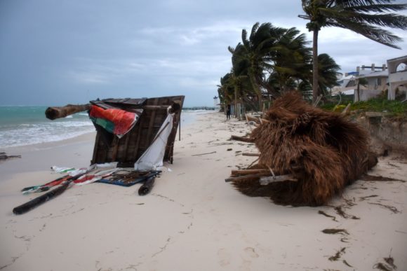
About the photo: Damages in Puerto Morelos, Quintana Roo state in Mexico, after the passage of Hurricane Zeta on October 27, 2020. Photographer: Elizabeth Ruiz/AFP/Getty Images
Was this article valuable?
Here are more articles you may enjoy.
 PG&E Says Power Shutoffs Required in California on Wildfire Risk
  Apple in Early Settlement Talks With DOJ Over Antitrust Case
  US P/C Industry Books Best Result in a Decade but Not All Lines Enjoy Success
  Software Firm CCC Intelligent Solutions Exploring Sale: Reuters
Want to stay up to date?
Get the latest insurance news
sent straight to your inbox.