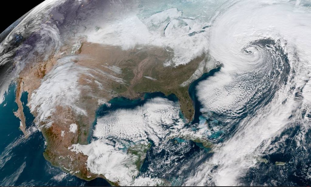
The $3.8 trillion municipal-bond market has found a new tool in its effort to understand the impact of climate change: the array of satellites orbiting high above Earth.
Assessing climate risks is a particularly vexing problem given that U.S. state and local governments tend to give investors information that’s often too little or just too late. But the use of geospatial data and information from sources like Google Earth could help municipal-bond investors evaluate and price the risks posed from a warming climate, rising sea levels and natural disasters.
The deployment of spatial technology in the municipal market advanced in January when credit-ratings company S&P Global Ratings completed an analysis of U.S. water utilities using data from National Aeronautics and Space Administration satellite missions. Other investment firms say they’re starting to focus on geospatial information as a way to evaluate climate risks as well.
“Largely, finance lives in columns and rows in Excel spreadsheets—climate change is not a row and column exercise,” said Chris Goolgasian, director of climate research at Wellington Management, a Boston asset manager that uses mapping technology to consider the impacts of climate change on investments like municipal bonds. “It’s much more powerful to see it visualized.”
The potential financial applications for the technology led researchers at the University of Oxford to coin the term “spatial finance” and to launch an initiative last year with groups like the Green Finance Institute to foster the use of geospatial data in markets.
Spatial finance takes advantage of the proliferation of satellites, which have become easier and cheaper to launch, as well as investors’ growing desire to consider environmental risks like climate change, said Christophe Christiaen, sustainable finance lead for U.K. technology company Satellite Applications Catapult, which is part of the initiative.
The municipal market could use the satellite data to monitor the impact of wildfires or natural disasters on local economies, Christiaen said. That is a “potential game-changer” he added. “What we want to achieve in the end is to mainstream this type of thinking.”
S&P, one of three big U.S. credit-ratings companies, used information from NASA satellites to examine whether the location of public water utilities had anything to do with their financial strength. They found that utilities located in ecosystems that foster better water quality, such as evergreen forests, were associated with better debt metrics.
Water utilities are a good sector to consider geography because of the potential for droughts or scarce supply in high-growth areas, making it especially necessary to consider climate change, said Ted Chapman, a senior director in S&P’s municipal and cooperative utility group. “That’s relevant to credit quality,” he said.
Adam Stern, co-head of research at the Boston-based Breckinridge Capital Advisors, said the use of such data—including information from satellites—will be an “indispensable” tool to understand the impact of climate change. The firm already considers the geography of certain municipal investments, such as whether they’re located in California areas at risk of wildfires.
“Most questions about climate change haven’t been answered in the muni market,” Stern said. “We’re just in the very beginning stages of getting our heads around the degree of risk that climate change poses to various issuers.”
Other financial markets could benefit from the spatial data too. Investec Asset Management, a South African asset management company, teamed up with the WWF – World Wide Fund For Nature on a report in 2019 about the potential to use spatial data as part of sovereign debt investing decisions. Satellite imagery could be used to help verify adherence to environmental policies, the report said.
Beth Burks, an associate director in the sustainable finance group at S&P, said the company plans to apply similar analysis to other credit markets, though she declined to say where.
“Where we go next is to try and increasingly experiment with these techniques in other areas of credit to broaden that capability,” she said. “We’re looking to really track this space.”
Was this article valuable?
Here are more articles you may enjoy.
 US Considers Creating Finra-Like Watchdog to Vet Top AI Models
  Study Explores Social Media’s Role in Tornado Disaster Communication
  Texas Floods, Canada Smoke and Western Heat Batter US
  PG&E Says Power Shutoffs Required in California on Wildfire Risk
Want to stay up to date?
Get the latest insurance news
sent straight to your inbox.