According to a public awareness project by the University of Illinois dubbed WW2010, in the early part of the century, coastal residents had less than a day’s notice of an impending hurricane.
But satellites have helped spur advances in hurricane forecasting, according to Dr. William Gray, professor emeritus of Atmospheric Science and head of the Tropical Meteorology Project at Colorado State University.
“The biggest advance has been in the track prediction. That has been amazing. The computers have been able to forecast track out to three, five, seven days — much better than they could previously,” said Dr. Gray.
Weak storms were often missed, he said.
“To make a prediction of how the storm was going to track the next one to three days was often difficult, because you didn’t often know the position of the storm,” he said.
Hurricane hunters, operated by the National Oceanic and Atmospheric Administration (NOAA), have also made a difference in hurricane prediction. Since their first flights in 1944, information is relayed by on board scientists to the Tropical Prediction Center for immediate analysis.
Not surprisingly, major hurricanes with sustained winds of 115 miles per hour do the most damage.
“They’re the ones with maximum sustained winds of 100 knots or 115 miles an hour. On a normalized basis, if you take the damage they do and put it in terms of coastal population, inflation and wealth per capita…they only take up about 15 to 20 percent of the number of named storms, but they do about 80 to 85 percent of the damage,” Dr. Gray said.
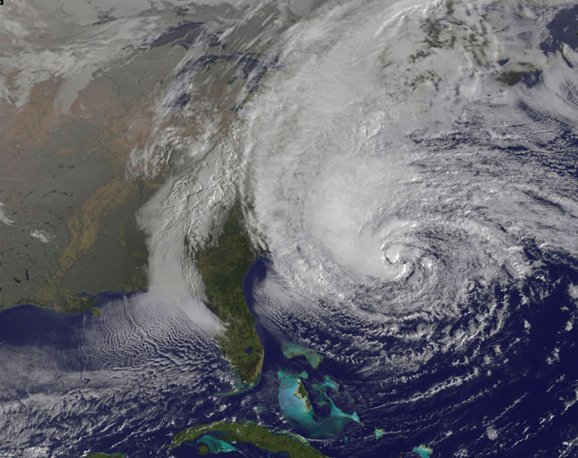
The last major hurricane, Superstorm Sandy, was predicted extremely well, according to Dr. Gray.
“Sandy was an anomaly. That wasn’t even a named storm when it made landfall,” added Dr. Gray. “What made Sandy so bad was the way it approached the coast. It came into south New Jersey, and was moving from the east. To the north of it, it had the winds blowing from the east, and those winds pushed the water against New York harbor, and into Long Island sound. Those were areas where the land came together, funneled to shorter things. When you have water funneled in like that, to land areas where the land around it is converging, you have extra water rise.”
“Sandy’s going to be the most economically damaging storm this country’s ever had. It will surpass Katrina, I think, in economic damage. Not in loss of life, but in economic loss,” Dr. Gray said.
Despite hurricane tracking advances, the professor urges readers to remember that every storm is different.
“The thing you must realize [is] that every storm is different. Like, some storms, the major damage will be wind, other storms, it’ll be surge. And others, it’ll be inland flooding from heavy rain. So, you have those three sources of damage from these storms,” Dr. Gray said. “In economic loss, every storm could be different, depending on the size of the storm, the arrangement of the coastline and how intense the center is compared to the outer winds,” Dr. Gray said.
Climate Change
Dr. Gray is not convinced that climate change is the driver of more recent weather catastrophes. Recently, he co-wrote a paper on the potential relationship between climate change and Superstorm Sandy.
“It doesn’t affect the motion of the storm, or the intensity, as far as I can tell. Despite what the climate changes are, warming or cooling, or whether the globe is cooler now, or warmer now, it doesn’t affect these short term steering currents, or how intense the storm’s going to be,” he said.
The big question is whether the globe is warming due to carbon dioxide increase, according to Dr. Gray,
“I don’t believe CO2 is causing the globe to warm much. Most of the warming that we’ve seen in the last century and a half, which is about point six degrees centigrade, is due to natural causes in my view. Storms are behaving much the same as they always have,” he said.
He points out that while carbon dioxide emissions have increased in recent years, the number of major hurricanes to make landfall in the United States has actually gone down.
“We have no reason to think that CO2 increases are making hurricane frequency or intensity around the globe or in the Atlantic by itself any different than it always has been. There are natural changes out there that are…in recent decades, making storms a little less frequent and a little less intense,” said Dr. Gray.
Was this article valuable?
Here are more articles you may enjoy.
 US Takes Aim at Autonomous Car Mishaps in Safety Rulemaking Push
  New EVs From Toyota, Subaru Breathe Life into Struggling Market
  US Hits Iran With Strikes, Blockade as Trump Plans Hormuz Charge
  Apple in Early Settlement Talks With DOJ Over Antitrust Case
Want to stay up to date?
Get the latest insurance news
sent straight to your inbox.