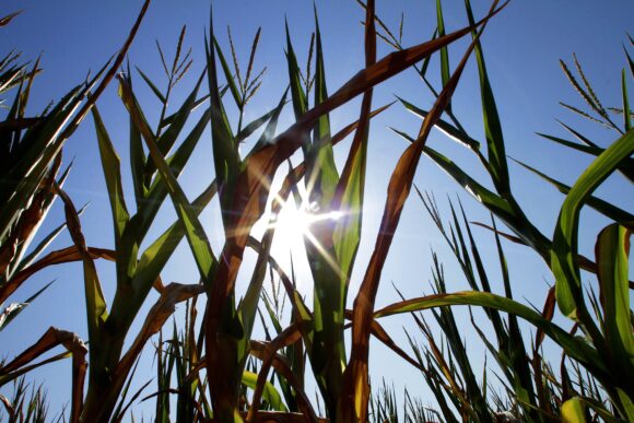
The withering U.S. corn crop is gaining some respite from a record heat wave this week but new weather forecasts offered scant signs of the rainfall it urgently needs to avoid the worst drought damage in nearly a quarter century.
As the majority of a near-record-size U.S. corn area is now set to enter the key phase of pollination, a period when hot and dry conditions can cause irrevocable damage, the lack of moisture threatens to extend a rally that has already propelled corn prices more than a third higher since mid-June.
“It is dry across much of the Midwest and Plains and there is no relief in sight,” said Alan Reppert, senior meteorologist at AccuWeather.com. He said the most affected areas were from Iowa to Illinois, the heart of the Corn Belt.

Chicago Board of Trade (CBOT) new-crop corn jumped 3 percent to a contract high, leading strong gains for the grain complex as unfavorable weather across the U.S. Midwest threatens crop yields further.
Front-month corn touched a high of $7.59-3/4 a bushel in Asian trade, not far from a record high of $7.99-3/4 set in June 2011 and spot-month soybeans rose to $16.48-3/4 a bushel, just below the all-time high of $16.63 notched in July of 2008.
“The good news for this week is that temperatures are due to slip back from last week’s record readings, the bad news is that all of the rain forecast is for the southern third of the nation,” ABN Amro analyst Charlie Sernatinger said in a note to clients.
He said Nebraska and Kansas had seen some rain over the weekend, but the eastern Corn Belt was unlikely to have any showers until the middle of next week, according to extended forecasts.
Analysts said the forecast rain in the southern Midwest is expected to bring only marginal relief to the crop baked in near-record heat.
“It looks cooler than last week and some rain is pushing into the region,” said one Melbourne-based analyst. “The question is how much rainfall, as of now it looks like below average rains.”
This week’s forecast for the U.S. grain belt calls for below normal rains and above average temperatures, said one trader citing U.S. weather forecasts.
“Dry weather will continue to stress crops across the Midwest until the weekend,” he said. “High temperatures will initially be in the 80’s, but quickly warm to the lower to mid 90’s by the weekend.”
The latest U.S. Drought Monitor report, released on Thursday, showed drought encompassing more of the contiguous United States than at any other time since the report began in January 2000.
The blistering heat has begun to ease, however, with a slow-moving front of cool air from Canada starting to push down temperatures on Sunday from Minneapolis to Detroit to Pittsburgh.
The temperature in Chicago, which had three consecutive days of triple-digit temperatures in the past week, was a pleasant 82 degrees Fahrenheit (25 C) early Sunday afternoon, according to the National Weather Service.
(Reporting by Jonathan Leff and Scott DiSavino; Additional reporting by Naveen Thukral in Singapore; Editing by Daniel Magnowski)
Was this article valuable?
Here are more articles you may enjoy.
 US Considers Creating Finra-Like Watchdog to Vet Top AI Models
  Texas Floods, Canada Smoke and Western Heat Batter US
  Taco Bell Offers $1 Lettuce-Free Enchirito to Win Back Customers Post-Parasite
  Insurance Woes Amid US-Iran War Stall Airlines’ Return to Dubai
Want to stay up to date?
Get the latest insurance news
sent straight to your inbox.