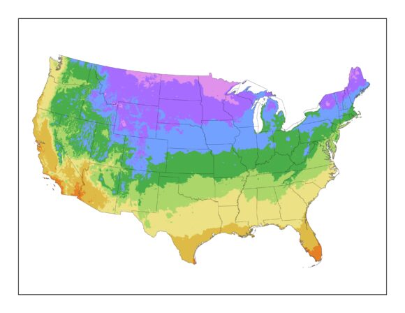
The government’s official map of colorful planting zones is being updated for a warmer 21st century.

The U.S. Department of Agriculture guide for 80 million gardeners reflects a new reality: The coldest day of the year isn’t as cold as it used to be. So some plants that once seemed too vulnerable to the cold now survive further north.
It’s the first time the government map has been updated since 1990 and much has changed. Nearly entire states, such as Ohio, Nebraska and Texas, are in warmer zones now.
Wednesday’s new guide also reflects better weather data and more interactive technology.
Copyright 2026 Associated Press. All rights reserved. This material may not be published, broadcast, rewritten or redistributed.
Was this article valuable?
Here are more articles you may enjoy.
 Clash of Florida Titans Pits Powerful Tribe Against Homebuilder Lennar
  Lawsuit Accuses Meta of Using AI to Target Workers With Medical Conditions for Layoffs
  Texas Floods, Canada Smoke and Western Heat Batter US
  What Home Age Actually Tells Us About Claims — And What It Doesn’t
Want to stay up to date?
Get the latest insurance news
sent straight to your inbox.