River levels are falling after record and near-record flooding in parts of the Midwest, but the crisis is far from over.
Downpours that dumped up to a foot of rain in parts of the nation’s midsection last weekend led to the sudden surge of water. Flooding is blamed in at least nine deaths, and an 18-month-old Arkansas girl swept away by floodwater is missing and presumed dead. Hundreds of homes and businesses were damaged in Oklahoma, Missouri, Arkansas and Illinois.
A steady rain that began Wednesday continued Thursday. The National Weather Service said the additional water – up to 4 inches of rain in some areas – shouldn’t cause rivers to rise higher, but will prolong the flood.
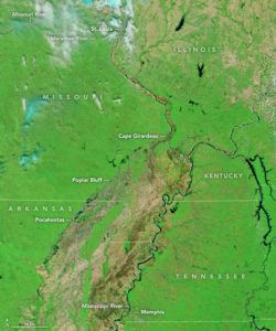
Major flooding is occurring on the Missouri River in eastern Missouri and the Mississippi River in Missouri and Illinois. A Mississippi River bridge at Chester, Illinois, closed at noon Thursday because flood gates on the Missouri side blocked the bridge entrance.
City officials in tiny West Alton, Missouri, about 20 miles north of St. Louis, urged residents to get out of town amid concerns the Missouri River levee there could break.
The worst of the damage was along smaller rivers.
The Black River that runs from southeast Missouri into northeast Arkansas was down after cresting at record levels earlier this week in places such as Poplar Bluff, Missouri, and Pocahontas, Arkansas. But the mess left behind was substantial. A levee breach near Pocahontas on Wednesday prompted several water rescues.
The Meramec River in suburban St. Louis also is on the decline. A levee at Valley Park, Missouri, is holding, as is a sandbag levee consisting of 250,000 bags in nearby Eureka. But the river remains dangerously high, and St. Louis County Police Chief Jon Belmar urged patience for evacuated residents anxious to get back home.
Hundreds of roads across the four states remain closed, including a busy stretch of Interstate 44 in suburban St. Louis.
Traffic is even closed on the Mississippi River. The U.S. Coast Guard late Tuesday closed a 14.5-mile stretch of the river near St. Louis, blocking a vital passageway for moving agricultural goods and other products.
Was this article valuable?
Here are more articles you may enjoy.
 Lawsuit Accuses Meta of Using AI to Target Workers With Medical Conditions for Layoffs
  Insurance Woes Amid US-Iran War Stall Airlines’ Return to Dubai
  Apple in Early Settlement Talks With DOJ Over Antitrust Case
  Insurer Interest in AI Exclusions Growing as Risk Becomes Omnipresent
Want to stay up to date?
Get the latest insurance news
sent straight to your inbox.