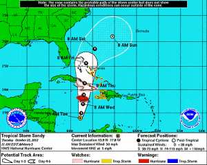
Tropical storm watches are in effect for Jamaica and Haiti (meaning tropical storm force winds are possible in the region in the next 48 hours) as the system tracks north towards the central Caribbean islands.
According to the National Hurricane Center (NHC), on Tuesday the center of Sandy was located over the Caribbean Sea about 375miles south-southwest of Jamaica. At this time, maximum sustained winds of 45mph were recorded, equating to a tropical storm on the Saffir-Simpson Hurricane Wind scale. Sandy is currently a moderate size storm with tropical storm force winds extending outwards up to 70 miles from the center.
Late Monday, Sandy became the eighteenth named storm of the 2012 Atlantic hurricane season.

According to the National Hurricane Center, Sandy is expected to strengthen during the next 24 hours and become a hurricane on Wednesday– before reaching Jamaica.
The official NHC forecast has tropical storm Sandy tracking to the north to north-northeast through to Friday. On this forecast track the center of Sandy will track over Jamaica late Wednesday, over eastern Cuba on Thursday, and over the eastern Bahamas on Thursday into Friday.
The storm is currently stationary over the warm waters of the southwestern Caribbean.
According to catastrophe modeling form Risk Management Solutions (RMS), the majority of models are calling for Sandy to strengthen to a hurricane. However uncertainty in the intensity forecast is reflected in the spread of the model intensity guidance from moderate tropical storm to a strong Category 1 hurricane.
RMS said that interaction with land masses as the system tracks over Jamaica and eastern Cuba and the movement of the system into an environment of increasing vertical wind shear are expected to weaken Sandy.
Sandy is forecast to be a tropical storm for the remainder of its track through the Caribbean. It is forecast to bring heavy rain to the central Caribbean, total rain accumulations of 5 to 10 inches, while there is the potential for the storm to bring isolated maximum accumulations of 16 inches that could produce life threatening flash floods and mudslides.
Source: RMS
Was this article valuable?
Here are more articles you may enjoy.

 California Jet Fuel Woes Deepen as Asia Flows Hit Decade Low
  Travelers to Expand Homeowners Insurance Offering in California
  Bayer Banking on US Supreme Court’s Help to Rein in Roundup Lawsuits
  US Weighs Tougher Auto Import Rules to Accelerate Reshoring