OCEAN CITY, N.J. (AP) — With some of the highest tides of the year set to arrive this week, New Jersey officials are launching a campaign to have residents document flooding in their neighborhoods and upload photos to a website that will automatically correlate them with weather and tidal information.
The goal is not only to build a database of frequently flooded areas, but to help the public view and understand the flooding they see in their neighborhood in the context of rising sea levels worldwide.
New Jersey is the 10th state to join the MyCoast website and app that lets people contribute information about flooding.
The public launch coincides with the arrival of so-called “king tides” from May 24 through May 29.
“The highest tides of the year offer a glimpse of what future seal level rise will look like,” said Vanessa Dornisch, ?a program coordinator at the ?Jacques Cousteau National Estuarine Research Reserve in Tuckerton.
They occur when the sun, Earth and moon align in a certain way, and happen in the spring and fall. Roadway flooding is frequently associated with king tides even in good weather; if they coincide with a storm, serious flooding could result.
The program calls for people to take photos of flooding in their neighborhoods and upload it to www.mycoast.org/nj. The best photos will win prizes from the Jacques Cousteau reserve including travel mugs, baseball caps and emergency kits.
The website or app will automatically append important information to each photo including what the weather was at the time, how near it was to the most recent high tide, temperature, wind speed and recent rainfall.
There also is a “places we love” page for residents to indicate which spots in the state they particularly enjoy.
The website had about 75 submissions as of last week, but it had only been publicized to a small amount of groups in something akin to a trial run.
The data will help educate state officials in making decisions about how to respond to climate change and rising sea levels. But it should also help the public understand why those decisions are being made in a larger context, said Nick Angarone, manager of the bureau of climate resiliency within the New Jersey Department of Environmental Protection.
“It’s too easy for people to see the issue in their front yard and not think about the broader implications,” he said.
It is not limited to ocean and bayfront areas; anywhere in New Jersey that is affected by tides can be part of the effort.
The state’s $25,000 annual subscription to the website is paid for by a federal grant.
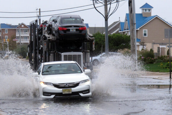
About the photo: Cars drive through a flooded road at the entrance to Long Beach Island in Ship Bottom, N.J. on Friday Oct. 11, 2019. A combination of high tides and strong winds was causing minor to moderate flooding in parts of the New Jersey shore, a cycle that was expected to be repeated Friday evening. (AP Photo/Wayne Parry)
Was this article valuable?
Here are more articles you may enjoy.
 Former Pro Soccer Players Show Brain Changes But No Cognitive Decline
  Insurance Woes Amid US-Iran War Stall Airlines’ Return to Dubai
  Clash of Florida Titans Pits Powerful Tribe Against Homebuilder Lennar
  Scientists Affirm Climate Change Fuels Extreme Weather
Want to stay up to date?
Get the latest insurance news
sent straight to your inbox.