USGS News

USGS: Nearly 75% of U.S. Could Experience A Damaging Earthquake

Nearly 75% of the U.S. could experience damaging earthquake shaking, a recent U.S. Geological Survey report shows. A USGS-led team of more than 50 scientists and engineers in the latest USGS National Seismic Hazard Model created a color-coded map that …

Displaced USGS Scientists Continue to Monitor Hawaii Volcanoes

Geologists who monitor Hawaii’s volcanoes are still among those displaced by the recent eruption of Kilauea. The Big Island eruption began on May 3 and destroyed more than 700 homes and started a series of collapse events at the volcano’s …

Researchers Use Planes to Map Oklahoma Earthquake Faults

Researchers are turning to the sky to help stop earthquakes from rumbling deep beneath the Oklahoma soil. The U.S. Geological Survey in coordination with the Oklahoma Geological Survey and other groups last week began using a modified small airplane to …

New Forecast Model Tries to Predict High Storm Waves

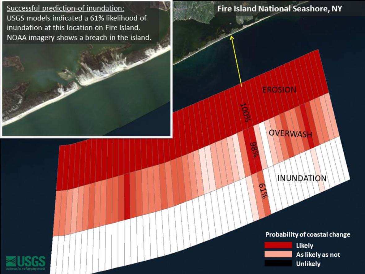
When John Couch is certain a storm will hit Hatteras Island, he goes into action, moving merchandise in his auto parts store from bottom shelves to top ones and hauling away the most valuable items. But at 64 years old, …

Limited California Quake Alert System Could be Operational by 2018

California Gov. Jerry Brown will seek state funds to help establish a system that issues alerts that an earthquake is occurring – with an eye on rolling out a limited system by 2018, a newspaper reported Monday. The governor will …

North Texas Earthquake Risk Higher Than Ever Before

A U.S. Geological Survey report concludes the risk of earthquakes for the Dallas-Fort Worth area is higher than it’s ever been. The USGS report released Monday, according to The Dallas Morning News, incorporates “induced” earthquakes into federal seismic hazard maps. …

Karen Clark & Company Releases Updated U.S. Earthquake Model

Karen Clark & Company (KCC) released a new U.S. earthquake Reference Model as part of the RiskInsight open loss modeling platform. The earthquake model is based on the latest 2014 US Geological Survey (USGS) report incorporating updated seismicity assumptions and …

Washington D.C. Sinking, May Drop 6 Inches by Next Century

New research confirms that the land under the Chesapeake Bay is sinking rapidly and projects that Washington, D.C., could drop by six or more inches in the next century—adding to the problems of sea level rise. This falling land will …

More Than 143M Americans Live in Earthquake-Prone Areas

More than 143 million people in the mainland states now live on shaky ground, earthquake scientists say. That’s because more people have moved into the quake-prone West Coast and some quake zones were recently expanded, according to researchers from the …

Arizona North Country Hit by Minor Quake

Northern Arizona experienced another earthquake early this morning, according to the United States Geological Survey. The federal agency reported the 4.7 magnitude earthquake could be felt in Sedona, Flagstaff and Cottonwood.