With a few weeks to go until the North Atlantic Basin enters its most active period, now is a good time to recap recent activity, review updated seasonal forecasts, and look ahead to what may be in store for the remainder of the season.
A Slow Start to the 2022 Season
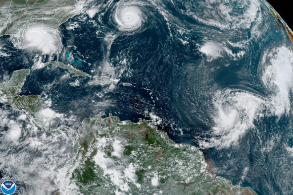
The North Atlantic Basin has been a little quiet since the start of the hurricane season. So far in 2022, the basin has not produced any hurricanes and just three tropical storms – Alex, Bonnie, and Colin:
- A tropical depression brought localized flash- and street-level flooding to parts of South Florida in early May and later developed into Tropical Storm Alex over the open waters of the western North Atlantic.
- Tropical Storm Bonnie developed in the western Caribbean Sea in early July and made landfall close to the border between Nicaragua and Costa Rica. It produced heavy rainfall that caused flash flooding and mudslides.
- Tropical Storm Colin developed while located over South Carolina in early July, bringing heavy rain to coastal areas of the Carolinas, but minimal impacts were reported.
Following the dissipation of Colin in early July, the North Atlantic Basin descended into an eerie calm with no named storms for over six weeks, which is unusual but not uncommon for the time of year.
This relatively slow start was driven by a combination of hurricane-inhibiting factors, including an abundance of Saharan dust over the main development region, increased vertical wind shear across the Caribbean Sea and central North Atlantic, and the propagation of the suppressed phase of the Madden-Julian Oscillation across the basin that created a generally more stable environment.
Have We Forgotten What Is Normal?
Has our perception of a normal start to the hurricane season been skewed by the last six seasons of above-normal activity and relatively early starts? Probably.
On average, the third storm of the year occurs on August 3. In 2022, it formed about a month earlier on July 2. Looking ahead, on average the fourth named storm of the year forms around now, in the middle of August, so we are not too far away from the current season keeping pace with climatology (Figure 1).
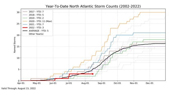
Looking back to August 2020, the tropical storm count had already reached double figures by mid-August, in a season that concluded with a record-breaking 30 named storms.
We’ve become accustomed to impactful pre-August 1 hurricanes because of the heightened early season activity in recent years, most notably Elsa (2021), Hanna (2020), Isaias (2020), and Barry (2019). But the first hurricane does not usually form until August 11, so recent seasons have been the exception to the norm.
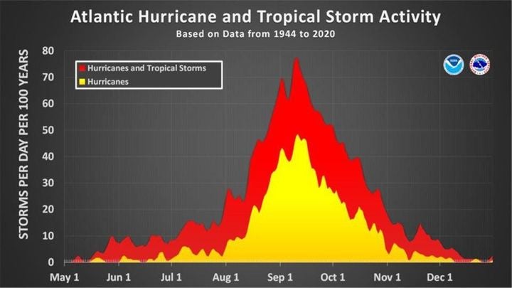
It’s also worth remembering that 90 percent of hurricanes and 95 percent of major hurricanes occur after August 1 (see Figure 2), and that tropical activity prior to August 1 has no significant bearing on how busy the rest of the hurricane season will be.
So, what does the rest of the season have in store, and will the perception of a quiet season hold for much longer?
Updated August Forecasts Still Call for an Active Hurricane Season
Despite the season’s slow start, a comparison of updated seasonal forecasts to preseason forecasts from late May and early June, issued by several leading weather agencies and groups, indicates an above-normal hurricane season is still most likely.
While the absolute number of storms, hurricanes, and major hurricanes forecast in 2022 has been slightly reduced compared to preseason forecasts, the totals still lie well above what an average hurricane season would produce, which typically consists of 14 named storms, seven hurricanes, and three major hurricanes.
The latest forecasts, inclusive of the three storms in June and July, are as follows:
- National Oceanic and Atmospheric Administration (NOAA) expects 14 to 20 named storms, six to 10 hurricanes, and three to five major hurricanes.
- Colorado State University anticipates 18 named storms, eight hurricanes, and four major hurricanes.
- Tropical Storm Risk forecasts 17 named storms, eight hurricanes, and three major hurricanes.
- The U.K. Met Office forecasts 16 named storms, six hurricanes, and four major hurricanes.
As discussed in my June RMS blog, if these forecasts verify, 2022 would be a record seventh consecutive above-normal season, extending the current ongoing record of six seasons dating back to 2016.
Atmospheric and oceanic conditions now present within the main development region are generally conducive for hurricane development. Most of these conditions are expected to last through the peak months of the hurricane season:
- Sea surface temperatures in the Gulf of Mexico and the western North Atlantic Basin are slightly above normal.
- The La Niña phase of the El Niño-Southern Oscillation (ENSO) appears to be sticking around for the foreseeable months.
- The West African monsoon has been stronger than average to date.
- The African easterly jet has shifted northward, and wind shear looks to soon diminish across the basin.
All these factors, as forecast ahead of the start of the season on June 1, are expected to result in an active remainder of the season.
Remember, it takes just one major event to turn a season – as we saw with Hurricane Ida last year. As a trusted partner, RMS is once again ready to inform critical business processes with reliable information and analytics during the year’s most challenging events, including through data supplied to our cloud-native applications such as RMS ExposureIQ™.
Be sure to keep an eye on the RMS Blog and our Twitter accounts @,RMS and @HWind, for the very latest information on tropical cyclone developments in the North Atlantic for the remainder of the season.
Was this article valuable?
Here are more articles you may enjoy.
 US P/C Industry Books Best Result in a Decade but Not All Lines Enjoy Success
  Texas Floods, Canada Smoke and Western Heat Batter US
  Insurance Woes Amid US-Iran War Stall Airlines’ Return to Dubai
  New York, California Sizzle as Extreme Heat Strains Power Grids
Want to stay up to date?
Get the latest insurance news
sent straight to your inbox.