The 2019 Atlantic Hurricane Center has been challenging the ground rules for an insurance industry organization that dispatches pilots to take aerial photographs immediately after natural disasters.
Usually, the Geospatial Intelligence Center doesn’t deploy aircraft or staff unless a Category 2 hurricane makes landfall. But the GIC’s “playbook” allows exceptions for special circumstances, saidCatastrophe Response Director Richard Butgereit.
Hurricane Dorian was 2019’s first “special circumstance.” Tropical Depression Imelda — a storm that sprung into existence on Tuesday and immediately beached itself on the swampy shores of southeast Texas — may be the second.
Butgereit said that the GIC may decide today whether Imelda is a second special circumstance that would merit sending him to Texas or order aerial photography to survey flood damages.
“I don’t have a good feeling about this one,” Butgereit said during an interview Thursday afternoon. “Last night I checked and there were no rescue calls and I thought this was off the plate. Today there’s very heavy flooding, lots of calls to 911 and rain is continuing over a very heavily populated area.”
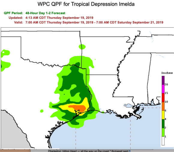
Heavy rain from the remnants of Imela was forecast to continue through the night, giving way to thunderstorms today. Gov. Greg Abbott declared a disaster in 13 counties as the National Weather Service reported “major, catastrophic flooding.”
CNN reported that the Harris County Sheriff’s Office had received 133 high-water rescue calls since noon. The Harris County Flood Warning System— which serves the Houston area — showed up to 20 inches of rain had already fallen in the Northeast portion of the county in the previous 24 hours. Another 10 to 20 inches was expected.
All this is putting the GIC at a trigger point: Whether to declare Imelda and Level 1 or Level 2 incident that requires a response. The center Tuesday declared Imelda a Level 3, which means GIC staff was closely monitoring it.
In a Level 2 event, the GIC begins to work remotely with public agency emergency services officials to share data. In a Level 1 event, it dispatches staff to emergency operations or incident command centers.
Butgereit said the approach of Hurricane Dorian earlier this month brought a hybrid response. “I did deploy, but we never collected imagery.”
Instead, Butgereit traveled from GIC headquarters in Boulder, Colorado to Tallahassee, where he kept an eye on the hurricane from the state emergency operations center. It was familiar territory: Butgereit worked for the Florida Division of Emergency Management before going to work for the GIC in November 2018.
Butgereit said he followed the storm as it moved north just off the Atlantic coast, eventually arriving at the North Carolina emergency operations center in Raleigh. But he never did dispatch any aircraft to take pictures of damaged properties. While Dorian skirted across the North Carolina coast, it landed as a Category 1 storm below the Category 2 threshold set by the GIC for a full-throttled response.
“Twenty to 40 miles off track and that thing would have been much worse for Savannah, Charleston, Hilton Head — all the way up the coast,” Butgereit said.
The GIC is a division of the National Insurance Crime Bureau. It operates two aerial photography programs for insurance carriers and their partners: Blue Sky and Grey Sky. The Blue Sky program is continuously ongoing: the GIC contracts with aerial photographs to take new photographs of every US address at 20 centimeters resolution once every year. Urban areas are photographed at an even higher 7.5 centimeters resolution.
GIC activates Grey Sky only after major disasters. It responds when called for by its playbook — or when its members decide to vary from that playbook. Aircraft are deployed over disaster areas as soon as it is safe to fly. GIC said it uses the Insurance Crime Bureau’s relationship with law enforcement to gain access to disaster areas, usually long before other aerial mapping providers are able to deploy.
Jim Schweitzer, senior vice president and chief operating officer for the National Insurance Crime Bureau, said the idea for the Geospatial Intelligence Center was born about four years ago while the organization was mulling over ways to better respond to natural catastrophes. Disasters such as storms and wildfires tend to lure shady contractors who prey on desperate homeowners, making it a natural area of interest.
The GIC took shape in late 2017 with the appointment of Ryan Bank as director. Schweitzer said the organization now has about 12 carrier members. It also shares its data with vendor partners of its member carriers. The center recently announced that data analytics providers CoreLogic and Arturo are using its data.
Schweitzer said the GIC developed its playbook as a means of controlling costs. Members of the group decided that they needed fresh images only after large-scale catastrophes.
“We are very cognizant of the fact that when you launch aircraft into the sky to start this imaging process, there’s a cost to that,” Schweitzer said.
However, on occasion members will ask the center to respond to disasters that don’t quite fit the playbook criteria. He said as of late Thursday, the organization was trying to decide whether to respond to the flooding caused by Imelda. Schweitzer said GIC members aren’t particularly interested in flood insurance — most of which is handled through the National Flood Insurance Program — but flooding can also impact commercial lines with business interruption and can lead to auto insurance claims.
He said the GIC was preparing late Thursday in case its members decide to deploy aircraft.
“As we speak, we are identifying flyers who are in the proximity to Houston and reaching out to members,” Schweitzer said.
Was this article valuable?
Here are more articles you may enjoy.
 Scientists Affirm Climate Change Fuels Extreme Weather
  New EVs From Toyota, Subaru Breathe Life into Struggling Market
  US Considers Creating Finra-Like Watchdog to Vet Top AI Models
  Clash of Florida Titans Pits Powerful Tribe Against Homebuilder Lennar
Want to stay up to date?
Get the latest insurance news
sent straight to your inbox.