Lately there has been a lot of media attention on the application of drones. Unfortunately, drones have assumed a negative connotation because of stealth military operations and privacy issues. As insurance pros, we need to view drones as simply another device in our toolbox. A tool that can provide valuable applications in property claims.
During the Enservio Property Innovation Summit this week, I plan to share specific examples of how drone technology could mean staggering leaps forward for property claims professionals.
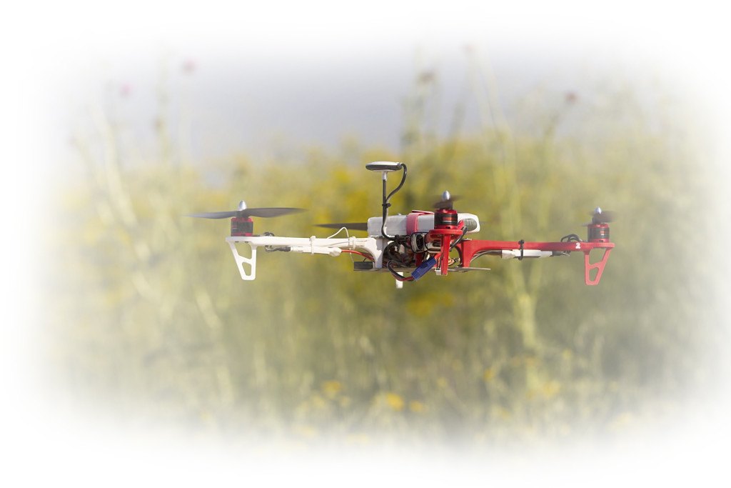
 Drone technology available for hobbyists is already well developed but shares little in common with military systems. The most straightforward ROI for the deployment of this flying hardware in our industry is roofing.
Using a camera-equipped drone, this hardware provides a paradigm shift in the way it collects data about a roof’s condition; especially important when it applies to collecting data on a high, steep, or fragile roof. Roof height alone can make it challenging for an adjuster or expert. The ground may not support a sturdy ladder, or the area may not easily permit access by a man-lift. In these instances, a drone suddenly becomes the perfect tool.
Another issue is steepness, or the actual pitch of a roof. Of late, many carriers have placed restrictions on authorizing employees from climbing up a certain degree of pitch. Personally speaking, I’ve inspected more than 1,000 roofs of various types for forensic engineering investigations. On too many occasions I’ve taken untold risk climbing steep roofs. It’s a dangerous line of work that poses a genuine safety issue. Using a drone can be a life-saver.
Some expensive roof claims derive from materials we classify as fragile, such as ceramic tiles and slate. In many cases, the damage done to these fragile surfaces are manmade and inadvertent. Damage may come from contractors and property owners, or from adjusters or experts who are simply trying to investigate a claim. To inspect roofs covered with these fragile materials, drones offer a brilliant solution.
The same is true for commercial property inspections, which present their own unique set of challenges. Large commercial buildings typically have low slope or flat roofs that suffer damage from hail, ice, or wind. A major issue with commercial buildings is size. It can be logistically difficult and expensive to generate comprehensive data on the condition of a roof when it is hundreds of thousands of square feet in size. In these situations, it’s not unheard of to discover a roof that is inconsistent in either its type of material or relative age. In a massive building, damage caused by a specific hail event can vary widely across the roof surface. Collecting comprehensive data in these situations can be time consuming. Industry standards call for making educated assumptions. Measurements are taken piecemeal, then compiled and extrapolated to account for the whole surface. But even educated assumptions can be misleading or flat out wrong. And why settle for inaccurate data when you can capture high resolution imagery of the entire roof with a drone?
Drones can be programmed to fly in a grid pattern, allowing one person to canvas a very large building (or development or agricultural property) in a matter of hours. The resulting data is high-resolution and comprehensive. It can be analyzed from the safety (and comfort) of a desk. A task that once involved multiple site inspections and consumed days’ worth of man hours can now be done in short order by a single person. These are tangible, real-world applications that translate to speed, savings and safety.
Another application area where drones may show transformational results is in CAT zones. Everything from setting reserves, to dispatching CAT teams, to determining how many people to deploy, and where to send these people, pose important financial decisions that must be made as quickly as possible in the wake of a CAT event. Today we’re making these decisions based on inaccurate or guesstimated data. And that’s not bad if it’s all you have.
A drone can be deployed within minutes or hours following a severe weather event. No need to dispatch aerial photography aircraft or wait for satellite imagery. Drones can be launched immediately after the event, flown below cloud level and without interfering in the activity of first responders. Imagery can be analyzed within hours thereafter from anywhere. GEO codes embedded in the data can be used to create maps. That means easy queries by address or latitude and longitude. High resolution translates to the ability to zoom focus to within inches of the investigated area. That means damage assessments can be done remotely. A CAT manager could know which properties are total losses and which are rebuilds before their teams put boots on the ground.
In the tangible future, all property claims professionals will be ingesting data that drones collect in their daily claims processes. Drones are currently without equal when it comes to collecting data in dangerous, fragile and hard-to-reach places. This flying hardware will keep adjusters and experts off roofs and off ladders. They also have the power to reduce cycle times and ensure more accurate claim payments, reduced premiums and lead to reductions in fraud. What on earth is wrong with that flight trajectory?
I will be speaking on drone applications in insurance to the nation’s top insurance executives on April 2 in Boston at the 2014 Property Innovation Summit. Other distinguished speakers presenting on innovation and leadership include keynoter Clayton Christensen of Harvard, COO Werner Kruck of Security First Insurance, and Oklahoma Insurance Commissioner John Doak.
Enservio Property Innovation Summit will conduct interactive workshops from a line-up of top thinkers, authors, and experts in management effectiveness and innovation. Attendees will gain key insights on new trends that can help transform their business. To inquire about attending, contact Joel Makhluf at jmakhluf@enservio.com or call (781) 292-6050.
Lyle Donan is president & CEO of Donan, a professional engineer, and the third-generation Donan to lead the family-owned forensic investigation firm. Donan has expanded its service offerings to include Fire Investigation, Component Testing and Lightning Investigation in addition to Forensic Engineering.
Was this article valuable?
Here are more articles you may enjoy.
 Berkshire Utility Presses Wildfire Appeal With Billions at Stake
  Portugal Rolls Out $2.9 Billion Aid as Deadly Flooding Spreads
  FM Using AI to Elevate Claims to Deliver More Than Just Cost Savings
  Tesla Sued Over Crash That Trapped, Killed Massachusetts Driver
Want to stay up to date?
Get the latest insurance news
sent straight to your inbox.