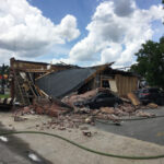
Flooding spawned by Hurricane Matthew has caused $1.5 billion in damage to 100,000 homes, businesses and government buildings in North Carolina, according to a state estimate.
The figure released late Saturday represents one of the first detailed analyses of damage from the storm, and it’s part of a growing picture of Matthew’s financial impact.
With floodwaters yet to recede in some communities, officials say the number could fluctuate.
“I do think that there may be more out there,” John Dorman, an assistant state emergency management director, said of whether the number could grow.
Dorman said the state’s computer modeling combines property records, topography and stream gauges to estimate how many feet of water have affected a given building – and how much damage that water caused. The state also used manned aircraft and drones to verify projections.
Damage estimates for buildings where the water only reaches the base of the foundation can be as low as $200 to $300, while estimates for buildings in which the water reach several feet are much higher, Dorman said. The system uses property tax values that are updated regularly and other calculations to estimate damage.
The figure released this weekend is one piece of the overall picture of how the storm affected the state. For example, it doesn’t include the cost of repairing damaged roads and bridges or replacing belongings inside damaged buildings, which are often covered by insurance policies.
Early next week, North Carolina Gov. Pat McCrory plans to release a detailed plan of how North Carolina will rebuild, including how to pay for the effort.
Even before the extent of the flooding was known, real-estate and insurance research firms had estimated that damage from Hurricane Matthew would be at least several billion dollars across multiple states.
In North Carolina, the hurricane dumped more than a foot of rain 100 miles inland, causing massive flooding in the eastern part of the state. Towns such as Princeville, Lumberton and Fair Bluff were inundated.
Meanwhile, in South Carolina, emergency officials are still closely watching the swollen Waccamaw and Little Pee Dee rivers.
Hurricane Matthew was blamed for killing at least 43 people in the United States – 26 of them in North Carolina – with most deaths caused by flooding. In Haiti, at least 500 storm-related deaths were reported.
Beyond estimating losses, North Carolina’s software directed rescue crews to areas where flooding was dangerous, and prompted evacuations of inmates from two facilities, Dorman said.
The computer mapping project began in the years after Hurricane Floyd in 1999. The state remapped North Carolina’s flood plains and collected data on more than 5 million buildings in the state.
“This is also helping to save lives and be operational, as opposed to just damage information,” Dorman said.
Was this article valuable?
Here are more articles you may enjoy.
 Navigators Can’t Parse ‘Additional Insured’ Policy Wording in Georgia Explosion Case
  Uber Jury Awards $8.5 Million Damages in Sexual Assault Case
  Portugal Rolls Out $2.9 Billion Aid as Deadly Flooding Spreads
  FM Using AI to Elevate Claims to Deliver More Than Just Cost Savings
Want to stay up to date?
Get the latest insurance news
sent straight to your inbox.