The U.S. Geological Survey is expected to release a new hazard map for earthquakes in Oklahoma.
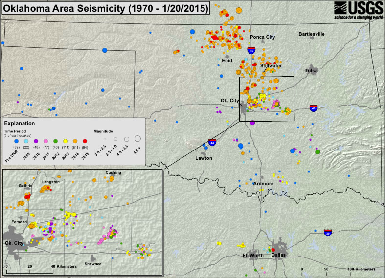
The Oklahoman reports that data collection has continued with the help of the Oklahoma Geological Survey after the state recorded more earthquakes of a magnitude of 3.0 and higher last year than California. The rate of 3.0 magnitude and higher earthquakes in Oklahoma has been 300 times higher over the past six years when compared to previous decades.
Their research, which was released earlier this month, said that reactivated faults in Oklahoma may be capable of causing larger seismic events.
“By identifying the faults, we are providing some guidance about where major earthquakes can happen,” Dan McNamara, USGS research geophysicist and lead author of the paper, said in a news release.
According to McNamara, current maps could be underestimating the earthquake hazard for Oklahoma and other states. The updated maps will include information about the type, length and location of the reactivated fault lines in the state. Risks from minor earthquakes caused by human activity will also be taken into account.
“Whether the seismicity increase is natural or is induced by wastewater injection, engineers, architects and regulatory bodies in the region should be aware of the current increased earthquake hazard in central Oklahoma,” the paper said.
The agency updated its national seismic hazard maps last year for the first time since 2008.
Was this article valuable?
Here are more articles you may enjoy.
 New EVs From Toyota, Subaru Breathe Life into Struggling Market
  CSU Lowers Atlantic Hurricane Forecast to ‘Well Below Normal’
  PG&E Says Power Shutoffs Required in California on Wildfire Risk
  After Losing Job and Crypto, Man Falsely Claimed $1.3M From 107 Class Actions
Want to stay up to date?
Get the latest insurance news
sent straight to your inbox.