View this article online: https://www.claimsjournal.com/news/national/2021/08/30/305678.htm
Hurricane Ida smashed into Louisiana with winds of about 150 miles an hour, driving a wall of water inland and leaving more than a million people in the dark. Yet only 36 hours before it reached land south of New Orleans on Sunday, the storm’s winds registered at just more than half that speed. In those critical pre-landfall hours, the storm underwent a process that scientists term rapid intensification — and this is where warming temperatures plays a pivotal role in generating more powerful hurricanes.
“It’s a known effect of climate change. Increasing ocean heat is causing strong hurricanes to become stronger,” said Greg Foltz, an oceanographer with the National Oceanic and Atmospheric Administration.
Hurricane Ida’s intensification meant that it made landfall as the strongest storm to hit Louisiana, now in a three-way tie with last year’s Hurricane Laura and the Last Island Hurricane of 1856. (It took from 1856 to 2020 for Laura to tie the Last Island hurricane record and it has only taken from 2020 to 2021 to tie it again.) The fact that Hurricane Ida’s wind speeds increased by more than 35 miles per hour within 24 hours meets the National Hurricane Center’s definition of rapid intensification.
 Multiple studies have shown that rapid intensification has increased over the past three decades, pushing large storms to become even larger. In the 24 hours before Hurricane Harvey made landfall in 2017, for example, its winds jumped from 90 mph to 130 mph — the difference between a Category One storm and a Category Four storm. In 2018, Hurricane Michael’s winds increased in speed by 45 mph in the last 24 hours before reaching in Florida.
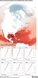
The reason hurricanes are getting more powerful with such speed is no secret: warmer ocean water. “Surface temperatures in the Gulf now are about 0.5° Celsius to 1°C above the 1971 to 2000 mean,” said Foltz. “This gives more fuel to hurricanes and increases their wind speed limit.”
The supercharging of Hurricane Ida came not just from warmer-than-usual surface temperature but also from a very warm blob of subsurface sea water. The storm passed over an eddy of water that measured 86° Fahrenheit (30°C) more than 100 feet below the sea surface in some areas, according to Argo sensors run by an international consortium of scientific agencies. These sensors collect data as they move with ocean currents, and there are now around three dozen in the Gulf of Mexico measuring conditions in the recent pathway of Hurricane Ida.
Argo, which has been deployed since 2000, has significantly improved understanding of how hurricanes interact with warming in deep waters. Satellites are excellent at tracking conditions in the atmosphere and on the surface of the ocean, but conditions beneath the sea are playing a crucial role in fueling storms. Argo sensors can capture temperature and salinity conditions up to 2 kilometers deep.
Before hurricane season, Foltz said the floats in the Gulf were programmed to surface every 10 days to transit their data via satellite. NOAA then switched the program to every two days to create a more continuous flow of data for hurricane season.
This helped NOAA predict that Hurricane Ida would grow rapidly because forecasters could see that there was no cold water deep down beneath the storm that would get churned up and mix with warm surface waters. The Argo sensors also revealed that water in the storm’s path was predominately saline, another factor adding to intensification.
In recent years, scientists have come to understand that deep water is fundamental to understanding a path of a hurricane. “Deeper warm water tends to be more conducive to hurricanes than shallow warm water because as a hurricane moves overhead, its winds churn up the water in a process called upwelling, which brings deeper water up to the surface,” said Kimberly Wood, assistant professor in the at Mississippi State University. “When that deeper water is a similar and also high temperature to the original sea surface temperature, that ‘new’ water will continue to provide fuel to the storm.”
By Monday morning, as Ida weakened to a tropical storm with 60 mph winds, new flood warnings traced its projected path from the Gulf to New Jersey. Meteorologists are also monitoring several weather systems, including newly formed Tropical Storm Kate, that have a chance of forming the next big storm made even bigger by warmer water.
–With assistance from Brian K Sullivan.
About the photo: Palm trees sway during Hurricane Ida in New Orleans, Louisiana, U.S., on Sunday, Aug. 29, 2021. Hurricane Ida barreled into the Louisiana coast on Sunday, packing winds more powerful than Hurricane Katrina and a devastating storm surge that threatens to inundate New Orleans with mass flooding, power outages and destruction. Photographer: Luke Sharrett/Bloomberg