
Recently used weather terms, including haboobs and derechos (pronounced day-ray-cho), may leave some wondering what the unfamiliar words mean. Weather experts say these terms have been around a long time and have just been picked up by mass media.
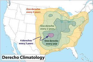
A derecho is defined as a widespread and fast-moving line of severe straight-line winds and bands of violent thunderstorms.

A recent derecho drenched Midwest and mid-Atlantic residents with its fast-moving thunderstorms and nearly 100 mph wind gusts. The Ohio Insurance Institute reported $433.5 million in insurance claims as a result of storms, including the derecho that occurred between July 29 and July 2.
Many of these storms have been around for a long time, said Dr. Harold Brooks who leads the Modeling, Observation and Analysis Team at the NOAA National Severe Storms Lab in Norman, Okla.
“Derechos have been around forever,” Dr. Brooks said, adding that the word was originally applied in the mid-1880s to describe a concentrated area of non-tornadic winds.
According to Dr. Brooks, the term derecho was coined because an early director of the National Weather Service didn’t believe the number of tornadoes being reported. An Iowa native, he coined the new term as a way to avoid using the word tornado in Iowa. Apparently, the frequent tornado reports made it less likely for new residents to move to Iowa.
“In general, the peak winds you would get in a derecho are not as high as the peak winds that occur in tornadoes. The high winds will cover a much larger area,” Dr. Brooks said.
A haboob, a term that has been used by the scientific community for many decades is a specific type of dust storm, according to Dr. Thomas Gill, an associate professor and graduate advisor of the Department of Geological Sciences at the University of Texas, El Paso.
“The term haboob comes from the Arabic from North Africa. It means something akin to strong wind. It’s been used for a very, very long time in Africa. However, meteorologists, and weather forecasters and scientists have used this term in North America for about 40 years or more,” Dr. Gill said.
The associate professor described the difference between a haboob and a regular dust storm.

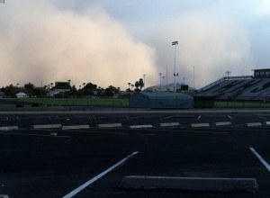
“A haboob is different from an ordinary dust storm in that’s it’s generally much more ominous appearing and much more threatening,” Dr. Gill said. “A haboob is like a giant wall or front of dust that blows in often to a clear, calm sky. Sometimes it almost comes out of nowhere.”
In North America, haboobs form as a result of very strong downdrafts of wind blowing out of thunderstorms, the associate professor said.
“They’re most common…in June and July…in Arizona, New Mexico, western Texas and southern California, where the ground is still very dry and sometimes even the thunderstorms are dry. So, when a blast of wind comes out of a thunderstorm out of a downdraft it picks up the dust and sand and blows it like this wall of dust that moves in,” said Dr. Gill.
Haboobs can lead to property damage.
“The damage is usually not so much from the dust and sand blowing in it…,” said Dr. Gill. “The biggest concern about a haboob is the winds because the winds are extremely strong. The haboob is actually caused by these extremely strong downdrafts blowing out of a storm. Winds can blow 40, 50, 60, 70 miles an hour or more, and the effects of a haboob can be like those of any strong wind storm objects being blown over, roofs and structures being damaged, and so on.”
Another local weather event associated with a particular region is high winds that can occur in certain parts of the world.
“…East of the Rockies they’re referred to as Chinook winds,” Dr. Brooks said. He said the phrase means snow eater.
According to the University Corporation for Atmospheric Research, the city of Boulder, Colo., often experiences these types of strong winds resulting in roofs being ripped off of buildings, snapped power lines and shattered windows totaling about $1 million in damage each year.
The strong, dry winds blow over the mountains and as that air comes over, it expands and comes down the slope off of the mountains warming the area dramatically. The temperature can rise 30 to 40 degrees in less than an hour, Dr. Brooks said.
Spearfish, S.D., holds the world record for the quickest observed temperature change — a 49 degree rise in two minutes. Chinook winds came down off the east side of the Black Hills and the temperatures rapidly rose, the storm researcher said. The winds, also seen in the Alps, are referred to as Foehn winds in Europe.