According to a National Oceanic and Atmospheric Administration bulletin highlighting changes in weather forecasting since Hurricane Katrina hit 10 years ago, the satellite data used by NOAA to forecast weather has improved quite a bit. The agency says three day forecasts made today are as accurate as the two day forecasts made 10 years ago.
Two types of satellites are used by the agency – geostationary and polar-orbiting – both of which provide real time data and imagery tracking of climate and weather changes 24 hours a day.
Orbiting 22,300 miles above the Earth, the Geostationary Operational Environmental Satellites, also known as GOES, supplies continuous imagery and measurements of air, land, water and ice across the Western Hemisphere. In their fixed position, the satellites offer meteorologists the ability to monitor severe weather conditions.
NOAA’s Goes satellite sent back an image every minute throughout Hurricane Katrina’s run from August 26 through 30.
Flying 540 miles above Earth, Polar-Orbiting Operational Environmental Satellites (POES) collect land, ocean and atmospheric data from the entire globe because the Earth rotates as these satellites travel from the North Pole to the South Pole. Data acquired from POES is used to create weather prediction models.
In 2016 the weather agency plans on launching the GOES-R satellite, which will enable the capturing of an image every 30 seconds during a major storm event and features significantly improved data collection capabilities.
Hurricane hunter planes were sent into the eye of Hurricane Katrina, but because of the potential danger to pilots in the future, NOAA plans to use an unmanned aircraft called the Coyote to monitor storms.
Additional tools being developed by NOAA include digital elevation modeling that will aid in flood forecasts and improved satellites that will supply continuous hurricane images to allow more lead time for hurricane watches and warnings.
Was this article valuable?
Here are more articles you may enjoy.
 These Five Technologies Increase The Risk of Cyber Claims
  Canceled FEMA Review Council Vote Leaves Flood Insurance Reforms in Limbo
 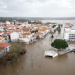 Portugal Rolls Out $2.9 Billion Aid as Deadly Flooding Spreads
  Charges Dropped Against ‘Poster Boy’ Contractor Accused of Insurance Fraud
Want to stay up to date?
Get the latest insurance news
sent straight to your inbox.