
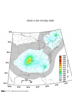
The city of Evansville, Ind., is getting a new set of earthquake hazard maps illustrating the areas at greatest risk of damage from strong earthquakes known to periodically shake southwestern Indiana.
The Evansville Courier & Press reports the maps will be unveiled to civic leaders and the public on Feb. 7.
Southwestern Indiana is at risk of quakes from both the New Madrid and Wabash Valley seismic zones.
U.S. Geological Survey geophysicist Oliver Boyd says the maps created with funding from the federal agency were developed based on a magnitude 7.7 earthquake from the New Madrid fault and a magnitude 6.8 earthquake from the Wabash Valley fault.
Boyd says the Wabash Valley fault poses a greater potential for damage in the Evansville-area because it’s closer to southwestern Indiana.
Was this article valuable?
Here are more articles you may enjoy.
 Insurers Want a Bigger Slice of the Bank Risk Transfer Boom
  Former NFL QB Hasselbeck on Frontier: Diagnosing CTE Disease in the Living
  A $100 Million Mall Reopening Is a Sign of LA’s Uneven Fire Recovery
  State Farm Must Give Up Trade Secrets in Claims Lawsuits, but Under Court Review
Want to stay up to date?
Get the latest insurance news
sent straight to your inbox.