According to catastrophe modeling firm AIR Worldwide, after rapidly dissipating on Monday night and being downgraded to a remnant tropical low, Manuel reformed and strengthened back to hurricane intensity on Wednesday. The re-formation was aided by a reduction in wind shear over the past two days, as well as by the storm having moved back over the warm ocean waters off the western coast of Mexico. Hurricane Manuel slowly drifted to the north-northwest at about 5 mph. This track, coupled with the storm’s slow forward speed, resulted in Manuel remaining over water for a longer period than was expected and allowed the storm enough time to regain hurricane status.
“Hurricane Manuel struck northwestern Mexico west of Culiacan at about 09:00 a.m. UDT today with maximum sustained winds around 74 mph (120 km/h) at landfall,” said Dr. Tim Doggett, senior principal scientist, AIR Worldwide. “This is the second time that the storm system has impacted the country. Mexico is still reeling from its arrival on the west coast near the port of Manzanillo on Sunday afternoon. Also, Hurricane Ingrid made landfall in the town of La Pesca on Mexico’s Gulf Coast on Monday— the first time since 1958 that the country has experienced two landfalling storms within 24 hours—and this double onslaught led to widespread flooding and landslides.”
Thousands of people are still trapped by the flooding, and in the popular resort of Acapulco powerful floodwaters ravaged hotels and stores. With both roads from Mexico City blocked by landslides and flooding and the airport terminal flooded, many travelers were unable to flee the devastation.
Dr. Doggett continued, “The short time between re-formation and landfall limited the extent of the storm, however, and Manuel remained a relatively compact tropical cyclone, with hurricane force winds only extending outward 15 miles (30 km) from the center of the eye, according to NHC reports. As Manuel moves inland, interaction with the mountainous terrain is expected to disrupt its circulation and steadily weaken the storm. The NHC has reported maximum sustained winds reduced to 65 mph (100 km/h) since landfall.”
“The small size of the storm will significantly limit the extent of any wind damage. However, heavy rainfall will be observed, especially in the mountains, and this will result in localized flash floods and landslides. The northern portion of Sinaloa and extreme southern Sonora will likely experience 8 to 12 inches of rain, and isolated maximum amounts of 20 inches are possible. Storm surge is expected to raise water levels along the immediate coast near and to the south of where the center makes landfall, by as a much as 2 to 4 feet, and will be accompanied by large and destructive waves.”
Manuel is on track to pass to the east of the city of Los Mochis, which has a population of more than 250,000, and head for the mountains inland. Most of the area that will be impacted is sparsely populated and either mountainous or agricultural. This coastal region grows many types of vegetables as well as sugar cane, cotton, rice, and flowers, and is a major producer of mangoes.
According to AIR, insured residential buildings in the region are predominantly of masonry and concrete construction, but it is estimated that each year up to 50 percent of new homes are constructed without a building permit. The commercial building stock in Mexico is quite heterogeneous and varies from poorly constructed low-rise masonry structures to well-maintained steel buildings.
Dr. Doggett concluded, “The principal cause of damage from Hurricane Manuel, however, is likely to be the heavy rainfall and the resultant flooding and landslides rather than wind. Well-constructed buildings are not likely to see significant damage, although damage to roof coverings and cladding may occur where they were poorly installed or have seen little maintenance over time.”
Source: AIR Worldwide
Was this article valuable?
Here are more articles you may enjoy.
 Canceled FEMA Review Council Vote Leaves Flood Insurance Reforms in Limbo
 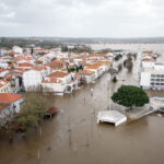 Portugal Rolls Out $2.9 Billion Aid as Deadly Flooding Spreads
  Uber Jury Awards $8.5 Million Damages in Sexual Assault Case
  Why 2026 Is The Tipping Point for The Evolving Role of AI in Law and Claims
Want to stay up to date?
Get the latest insurance news
sent straight to your inbox.