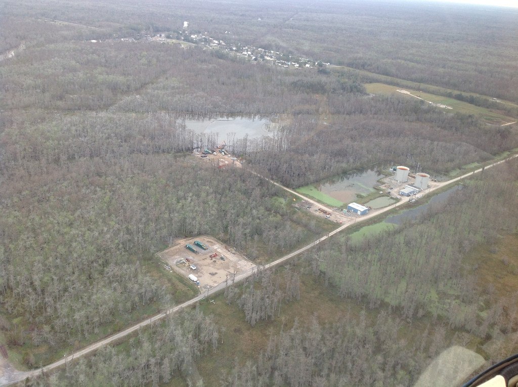
The Louisiana Office of Conservation has modified orders requiring Texas Brine Co. LLC to assess the status of sediments under an 8.5-acre sinkhole in northern Assumption Parish, prompting the company to withdraw a lawsuit filed last month against the state.
The Advocate reports the state agency and the Houston-based company were set for a hearing at 9 a.m. Tuesday before state District Judge Wilson Fields in Baton Rouge. Texas Brine spokesman Sonny Cranch says the company’s Dec. 28 lawsuit was withdrawn as a result of the amended order released Monday.
About 150 households in Bayou Corne and Grand Bayou have been evacuated since Aug. 3, the day the sinkhole was discovered.

In the amended order by Conservation Commissioner James Welsh, Texas Brine will no longer be required to drill two 6,000-foot deep wells on either side of the sinkhole between Grand Bayou and Bayou Corne. The two wells were the focus of Texas Brine’s lawsuit.
Instead, the company will be required to perform 3-D seismic imaging from the surface along with other measures to get a better picture of the substrata scrambled by the failure of Texas Brine’s abandoned cavern that is thousands of feet deep.
The salt cavern in the Napoleonville Dome has been the suspected cause of the sinkhole and the source of subterranean oil and gas releases in the area, scientists have said. But the Office of Conservation and their scientists want a seismic picture of the subsurface to better understand what is happening.
The Texas Brine lawsuit sought to block Welsh’s Dec. 7 order calling for the two 6,000-foot wells. The company had argued that the deep wells would take too long and pose a risk to the community when quicker, safer methods were available.
Cranch said the company was preparing to do the 3-D seismic work on its own and had finished the first part of another kind of seismic testing called a vertical seismic profile.
Office of Conservation officials said Monday they originally wanted Texas Brine to do the 3-D work, but the company estimated it would take two years to get results and it was concerned about landowner access. Since the December order, Texas Brine has changed its estimate of the time needed to do the 3-D seismic survey, saying it could be finished by April.
Texas Brine now has until April 21 to complete the survey and turn over the data to the Office of Conservation.
“Texas Brine has indicated it can meet this shorter timeline by using 3-D seismic imaging,” Welsh said in the statement, “and we hope this is a sign that the company is finally beginning to respond with the sense of urgency required in responding to this ongoing situation.”
Was this article valuable?
Here are more articles you may enjoy.
 Supreme Court Allows More Transport Workers to Bypass Arbitration and Sue Employers
  Travelers Survey: Distracted Drivers Making US Roads More Dangerous
  Johnson Controls Unit to Pay $750M to Settle ‘Forever Chemicals’ Lawsuit
  Texas Among Several States Facing New Fire Risks: Weather Watch
Want to stay up to date?
Get the latest insurance news
sent straight to your inbox.