Advancements in weather prediction tools have allowed the National Hurricane Center (NHC) to introduce two new products, a storm surge flood prediction map and a five day tropical weather graphical outlook map this year.
James Franklin, branch chief of the Hurricane Specialist Unit at the NHC in Miami, Fla., explained that his unit of 10 forecasters is responsible for forecasting hurricanes.
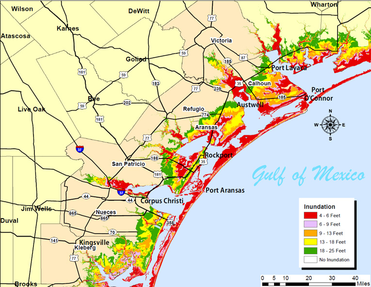
The storm surge flood prediction map is a detailed depiction of a reasonable worst case scenario for inundation from storm surge, Franklin said.
“This map now takes our official forecast and the possible errors that could be associated with that forecast, runs a surge model…and we come up with a map showing the risk of various levels of inundation,” said Franklin.
The NHC also introduced a five-day tropical weather forecast map which not only depicts where the disturbance is now, but also highlights…a swath showing where that formation could occur over the next five days, Franklin said.
“It gives people an idea of what the likelihood of formation is and where these disturbances are likely to go, the NHC branch chief said.
Anticipated tools to be introduced sometime in the future include track forecast improvements, a storm surge warning and early tropical storm warnings.
“Our track forecasts, for example, have been getting better year by year. Since 1990, our 48 hour track errors have come down from 200 nautical miles on average to about 70,” Franklin said. “Our three day forecast errors have come down in that period from about 300 nautical miles to 100 today.”
According to Franklin, intensity errors have remained stable while storms have gotten stronger in a shorter amount of time.
“There is some hope on the horizon for that. There’s a program called the Hurricane Forecast Improvement Program. It is a 10 year program. We’re about five years into it. It’s been the first real application of serious money for improving hurricane forecasts in my career, and I’ve been doing this for about 30 years now,” said Franklin.
To improve forecasting of these so-called rapid intensifying storms, the NHC is looking into high resolution computer models and considering using data obtained from reconnaissance aircraft.
He said the NHC is working very hard to introduce a storm surge warning.
“We’re also working very hard to advance our storm surge guidance that we’re putting out. We hope next year to have an experimental storm surge warning. Right now, we have a hurricane warning and a tropical storm warning. Those are basically for wind, but we don’t have in the weather service a warning for the hazard that kills more people than any other hazard, and that’s that storm surge. We’re working on that development. We hope next year or perhaps in 2016, to have an explicit warning for the storm surge threat,” Franklin said.
The NHC also anticipates issuing tropical storm warnings for systems before they become tropical depressions.
“Right now, we can’t issue warnings until the cyclone forms. Very often, we would have a good idea of what areas might be threatened even before the cyclone forms. That may be another new warning that comes into play next year or perhaps a year after that,” said Franklin.
The NHC is also completing in house experiments with six and seven day forecasts.
Was this article valuable?
Here are more articles you may enjoy.
 Texas Among Several States Facing New Fire Risks: Weather Watch
  Oregon Schools Sued for $9M After Young Girl Allegedly Raped
  EVs Head for Junkyard as Mechanic Shortage Inflates Repair Costs
  Hawaiian Electric Hits 40-Year Low Ahead of Maui Fire Report
Want to stay up to date?
Get the latest insurance news
sent straight to your inbox.