As the headline implies, there is a lot to watch in the Atlantic and the Pacific in the next few days. While all the world’s oceans may not be represented, Europe, Asia and North America will all get a chance to feel the effects of a full range of storms currently out across the Atlantic and Pacific.
We’ll start in the Atlantic, where Tropical Storm Bertha is stumbling north offshore from the U.S. East Coast on its way to transitioning to a post-tropical storm later this week, before clipping southern Newfoundland, according to the National Hurricane Center in Miami.
Essentially, this means Bertha will become just another North Atlantic storm fading in relative obscurity, unless you have weekend plans in London or Dublin. In that case, it’s going to be wet, windy and gray.
Of course, that pretty much described conditions across all of Ireland yesterday, according to Met Eireann. So will anyone notice?
Based on U.S. Ocean Prediction Center forecasts, Bertha’s biggest impact in the U.S. will be 5- to 10-foot (1.5- to 3- meter) waves along the coast of New England. While waves like that probably wouldn’t even get a mention in a Beach Boys’ song, the surfers in Rhode Island’s Narragansett Bay will be happy.
Pacific Storm
Things in the Pacific won’t be quite as fun.
In his blog yesterday, Weather Underground’s Jeff Masters pointed out that hurricanes are rare in the Hawaiian Islands, so imagine how lucky they must be to find themselves in the shadow of two storms in one week. The Capital Weather Gang at the Washington Post said there hasn’t been back-to-back strikes from named storms in Hawaii in records dating to 1950.
Hurricane Iselle, which was a Category 4 monster on the five-step Saffir-Simpson scale earlier this week, is forecast to ride over the Big Island in two days as at least a tropical storm, which means it will have winds from 39 to 73 miles (63 to 117 kilometers) per hour.
The big threat from Iselle will be heavy rains across the mountains that could touch off mudslides and flooding, said Paul Walker, a meteorologist with AccuWeather Inc. in State College, Pennsylvania.
Right behind Iselle is Julio, which grew from a tropical storm into a hurricane today. It’s moving west across the Pacific about 1,750 miles east of Hilo and is forecast to strengthen.
Julio may arrive off the coast of the Big Island still at hurricane strength by this weekend, according to the hurricane center.
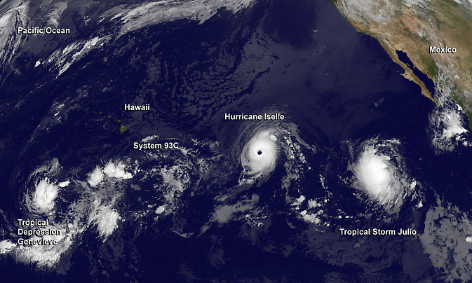
Image Credit:
NASA/NOAA GOES Project
Japan, Too
If that isn’t enough, Japan is back in the sights of a tropical system. The country took a direct hit when Typhoon Neoguri went ashore on Kyushu in early July. The U.S. Navy Joint
Typhoon Warning Center in Hawaii is advising that Typhoon Halong may strike Shikoku head on and soak Kyushu by this weekend.
Halong had winds of close to 98 mph yesterday, making it a Category 2 storm on the Saffir-Simpson scale used in the U.S. The U.S. and the much of the rest of the world differ in how the winds in tropical systems are measured.
The U.S. measures winds for one minute at a height of 33 feet, while other countries, including Japan, use the same height but take readings for 10 minutes. This means that wind speeds reported by U.S. agencies can’t be compared directly to those in other countries.
Tracking Tracks
The big thing to watch when it comes to Halong, as well as Iselle and Julio, are the tracks.
The storms are still days away from any potential landfall and a lot can change in the coming days, both in terms of intensity as well as where the storms eventually end up.
In the case of Halong, the potential for flooding is high. Six to 12 inches of rain may fall where the storm goes ashore and some areas could see more than that, according to Eric Leister, a meteorologist at AccuWeather.
This comes after moisture from tropical storm Nakri dropped rain by the foot across some areas of Japan last weekend, Leister said.
And I almost forgot, which is easy to do given everything else that is going on, Tropical Depression Genevieve is kicking around out in the middle of the Pacific far from anywhere. It might make it to tropical storm strength later this week as it passes between Midway and Wake islands.
Was this article valuable?
Here are more articles you may enjoy.
 California Chiropractor Sentenced to 54 Years for $150M Workers’ Comp Scheme
  Travelers Survey: Distracted Drivers Making US Roads More Dangerous
  Dog-Related Injury Claim Payouts Hit $1.12B in 2023, Report Shows
  Oregon Schools Sued for $9M After Young Girl Allegedly Raped
Want to stay up to date?
Get the latest insurance news
sent straight to your inbox.