Karen Clark & Company (KCC), independent experts in catastrophe risk, catastrophe models and catastrophe risk management, issued a report in conjunction with the one-year anniversary of Superstorm Sandy that estimates $300 billion of property value in Sandy’s flood footprint and nearly $50 billion of flood damage to properties.
The report examines the unique aspects of the storm, the Northeast’s vulnerability to coastal flooding and how future storms could be worse than Sandy. The report also reviews the legacy of the storm and its impact on insurers and coastal communities. The full report is available at www.karenclarkandco.com.

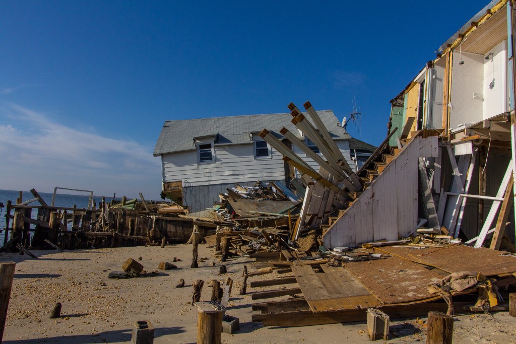
Sandy came ashore near Atlantic City on a path nearly perpendicular to the New Jersey coastline on October 29, 2012. At landfall, the storm was characterized by the National Hurricane Center as a post-tropical cyclone with hurricane-force winds. Tropical storm force winds stretched nearly 1,000 miles across the circulation. Due to Sandy’s immense size and unusual northwesterly track, high winds extended throughout the Mid-Atlantic and Northeast. The winds caused damage well inland along with power outages and disruptions to transportation and communications. The greatest impact, however, was along the coast, with severe damage caused by flooding from Sandy’s extensive storm surge, which measured 14 feet in some areas. Total losses for the storm are estimated at $65 billion, with the insured portion just under $20 billion.
“While not the most expensive storm to impact the U.S. coastline, Sandy was the most costly borderline Category 1/tropical storm to make landfall in the historical record,” said Karen Clark, president and CEO, KCC. “A rare combination of several meteorological phenomena occurred as Sandy was moving up the East Coast resulting in its unusual track. This path, combined with the storm’s immense size resulted in damages much greater than expected for such a weak hurricane.”
The Northeast United States is particularly vulnerable to storm surge given its relatively shallow coastal waters, presence of inlets, bays and rivers, and local topography. In addition, a storm that makes landfall perpendicular to the coastline, as Sandy did, will produce a higher surge than the same storm moving parallel to the coast or coming ashore at a different angle. Storms with broad circulations also create a greater amount of surge than smaller storms.
KCC’s RiskInsight platform, which was recently updated to include storm surge flooding, provides detailed, high-resolution elevation data and can be used to identify areas and properties likely to be impacted by storm surge. RiskInsight estimates $300 billion of property value in Sandy’s flood footprint and nearly $50 billion of flood damage to properties.
Future storms could prove much more damaging than Superstorm Sandy. For example, the Great New England Hurricane of 1938, if it were to happen today, would likely cause insured losses at least twice those of Sandy. The storm surge heights would be similar, although in different locations, with the most significant inundations along the coasts of eastern Long Island, Connecticut, Rhode Island and southern Massachusetts. RiskInsight estimates a repeat of the 1938 storm would cause flooding and wind damages totaling over $100 billion.
“Sandy’s large size and right-angle approach to the coastline greatly enhanced the storm surge,” said Clark. “Had Sandy followed a more typical path parallel to the coast, the surge would have been much less, particularly in New Jersey, Staten Island, and Queens. Given Sandy’s unusual characteristics, the likelihood of such a storm occurring again is very low, but future storms following more probable tracks and causing more extensive damage are much more likely.”
Sandy’s unusual track was due primarily to the position of the jet stream. Some scientists have speculated that climate change is weakening the jet stream and increasing its tendency to meander. A climate scientist at Rutgers University has suggested the northward swings in the jet stream, like the one that existed at the time of Sandy, are happening more frequently, and that one month before Sandy, the Arctic sea ice extent reached a record low. That said, scientists generally agree that a direct link can’t be made between low sea ice and Sandy’s track. There is however widespread agreement that continuing sea level rise contributed to the significant storm surge damage from Sandy.
“The current scientific consensus is that climate change is not likely to produce more tropical cyclones but might in fact result in fewer but more intense storms,” Clark said. “That said, flooding damage from all types of storms will be exacerbated as ocean levels continue to rise.”
“Sandy has heightened awareness of the threat of the hurricane hazard in regions where the historical frequency has been low,” Clark said. “Sandy clearly demonstrates that even weak tropical systems can cause tremendous damage in the Northeast, primarily because storms tend to be large in this region and there are such high concentrations of property values. While Sandy was devastating to many coastal communities, there have been positive outcomes such as increased dialogue at the local, state and federal level on coastal hazards and how to mitigate the impacts of future storms.”
Source: Karen Clark & Company
Was this article valuable?
Here are more articles you may enjoy.
 BNSF Says It Didn’t Know About Asbestos That’s Killed Hundreds in Montana Town
  Zurich, Philadelphia, Others Ordered to Pay $345M to Cover Abuse Charges at Georgia School
  Sanofi to Pay $100 Million to Settle Zantac Cancer Lawsuits
  Gallagher: Global Insured Natural Disaster Claims Again Dominated by Severe U.S. Storms
Want to stay up to date?
Get the latest insurance news
sent straight to your inbox.