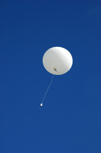
Every day, twice a day, researchers launch an 8-foot-tall helium-filled balloon on a 90-minute meteorological suicide mission.
As it reaches the troposphere – three times higher than commercial jet traffic – the balloon expands to the size of a garage and bursts, but not before transmitting Earth’s vital statistics: temperature, wind speed, moisture and air pressure.
 The launches, which occur at the same time at sites across the United States and around the world, are one of the few forecasting techniques that haven’t changed in decades.
“The idea of launching an instrument packet and having it radio telemetry back is pretty much the same as it was in the 1940s,” said Seth Binau, science operations officer for the National Weather Service in Wilmington, Ohio.
“It’s just that our methods of measuring and detecting the signal have advanced.”
After the balloon bursts, a GPS transmitter packet the size of a large sandwich parachutes to Earth with a message to those who find it: “Harmless Weather Instrument.” About 10 percent are recovered.
Data from balloons, satellites, airport radar and private weather stations are pumped into computers at the National Centers of Environmental Prediction in College Park, Md., where scientists use “the laws of meteorology and physics equations to start forming forecasts,” Binau said.
“We’re not sitting here with our fingers up in the sky.”
This data patchwork is woven using mathematical algorithms into twice-daily forecasts that guide television newscasts and alert local officials who declare snow emergencies, school closings and tornado watches.
Transmission towers and wind vanes dot the grounds outside the Wilmington office in rural Clinton County southwest of Columbus and those outside 121 similar stations nationwide.
If the weather balloons are the slow-moving legs of the operation, the tower-mounted Doppler radar – introduced in the United States in the early 1990s – is its darting eyes and twitching ears.
The radar, housed in a tower topped by a 30-foot globe, emits microwaves across the land and sky. Changes in frequency in the signal that returns accurately measure velocity in wind shear, cloud rotation and rainfall.
Years ago, local sheriffs had to spot a tornado to issue a warning. Today, Doppler is a meteorologist’s most important tool in making that call.
Still, trained eyes are needed. Hundreds of weather observers, many with backyard weather stations, help the weather service.
“If we happen to see funnel clouds, that’s where weather spotters really fill the gap,” said John Montgomery, a retired banker and president of Central Ohio Severe Weather Network. “We’re on the ground and can see what’s happening.”
During severe storms, Montgomery and others man an office at Port Columbus and relay information to Wilmington from a network of spotters, many who use ham radios to communicate.
Even though it’s a team forecast, Wilmington is solely responsible for getting it right and for issuing warnings.
That responsibility comes with pressure.
“None of us wants to not issue a warning and then to hear that a home was demolished and kids were killed,” Binau said. “There’s no worse feeling in the world. You feel like you had a hand in their death.”
Was this article valuable?
Here are more articles you may enjoy.
 Zurich, Philadelphia, Others Ordered to Pay $345M to Cover Abuse Charges at Georgia School
  California Sees Two More Property Insurers Withdraw From Market
  CoreLogic Report Probes Evolving Severe Convective Storm Risk Landscape
  J&J, Kenvue Told to Pay $45 Million to Baby Powder User’s Family
Want to stay up to date?
Get the latest insurance news
sent straight to your inbox.